Click to visit the main New York Public Library Homepage
The New York Public Library
Digital Collections
About Digital Collections
Browse
Search only public domain materials
Items
Collections
Divisions
Home
Search
Browse
About
Search only public domain materials
Items
Collections
Divisions
Digital Collections
Using Images
Using Data
Search
Filtered keyword search
Show filters
Hide filters
Show Only Public Domain
topic
Real property
155
Business enterprises
130
name
x
D.G. Beers & Co
Bourquin, F. (Frederick), 1808-
41
Worley & Bracher
41
collection
Atlases of the United States
156
place
New York (State)
155
Steuben County (N.Y.)
56
Steuben County
55
Columbia County
41
Columbia County (N.Y.)
41
More
Less
genre
x
Atlases
Maps
143
Title pages
3
publisher
D.G. Beers
56
D. G. Beers & Co
41
J.H. Toudy & Co
34
division
x
Map Division
type
cartographic
143
text
17
Date Range
to
156 results found for:
x
map
Filtering on:
x
Division
: Map Division
x
Genre
: Atlases
x
Name
: D.G. Beers & Co.
Sort by:
Relevance
Title
Date created
Date digitized
Sequence
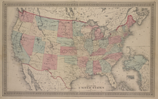
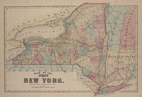
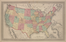
Map
of The United States
note:
Township
maps
are on the scale of 1:42,240 or 1
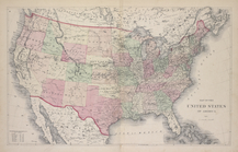
Map
of The United States of America
Index.
note:
Township
maps
are on the scale of 1:42,240 or 1
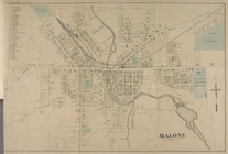
Malone [Village]
note:
Township
maps
are on the scale of 1:42,240 or 1
Plan of the states of New Yor…
note:
Township
maps
are on the scale of 1:42,240 or 1
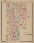
Outline plan of Franklin Co.
note:
Township
maps
are on the scale of 1:42,240 or 1
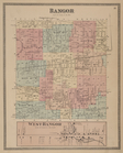
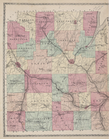
Bangor [Township]; West Bango…
note:
Township
maps
are on the scale of 1:42,240 or 1
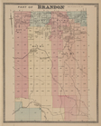
Part of Brandon [Township]
note:
Township
maps
are on the scale of 1:42,240 or 1
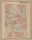
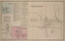
Chateaugay [Township]
note:
Township
maps
are on the scale of 1:42,240 or 1
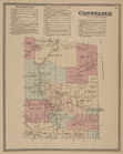
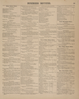
Constable Business Notices. ;…
note:
Township
maps
are on the scale of 1:42,240 or 1
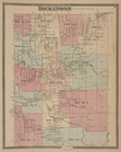
Dickinson [Township]
note:
Township
maps
are on the scale of 1:42,240 or 1
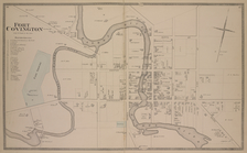
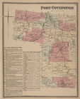
Fort Covington [Village]
note:
Township
maps
are on the scale of 1:42,240 or 1
Malone [Township]
note:
Township
maps
are on the scale of 1:42,240 or 1
Business Notices.
note:
Township
maps
are on the scale of 1:42,240 or 1
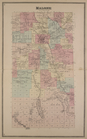
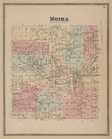
Moira [Township]
note:
Township
maps
are on the scale of 1:42,240 or 1
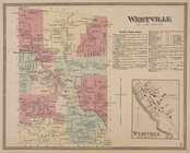
Westville [Township]; Westvil…
note:
Township
maps
are on the scale of 1:42,240 or 1
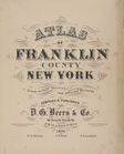
Atlas of Franklin County, New…
note:
Township
maps
are on the scale of 1:42,240 or 1
Outline
Map
of Steuben Co.
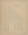
Table of Distances. ; Post Of…
note:
Township
maps
are on the scale of 1:42,240 or 1
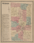
Burke [Township]; Town of Bur…
note:
Township
maps
are on the scale of 1:42,240 or 1
Fort Covington [Township]; Fo…
note:
Township
maps
are on the scale of 1:42,240 or 1
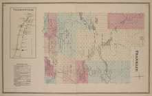
Vermontville [Village]; Frank…
note:
Township
maps
are on the scale of 1:42,240 or 1
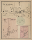
Brush's Mills [Village]; Moir…
note:
Township
maps
are on the scale of 1:42,240 or 1
Map
of The United States
Bangor [Village]; Bagor Busin…
note:
Township
maps
are on the scale of 1:42,240 or 1
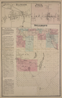
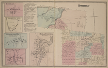
Bombay [Village]; Goodwins Mi…
note:
Township
maps
are on the scale of 1:42,240 or 1
Burke [Village]; Burke Busine…
note:
Township
maps
are on the scale of 1:42,240 or 1
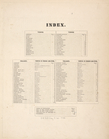
Index
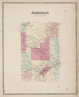
Addison [Township]
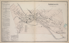
Addison Business Notices; Add…
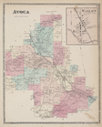
Avoca [Township]; Wallace [Vi…
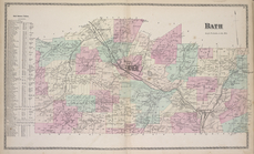
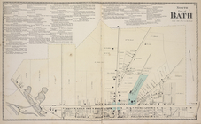
Bath Business Notices; Bath […
Bath Business Notices; North …
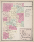
Cameron [Township]; Cameron B…
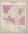
Campbell [Township]; Adrian […
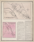
Campbelltown [Village]; Curti…
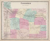
Canisteo [Township]
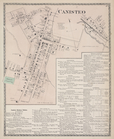
Canisteo [Village]; Canisteo …
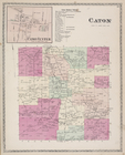
Caton Center [Village]; Caton…
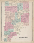
Cohocton [Township]
Centerville [Village]; Cornin…
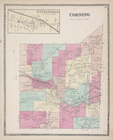
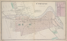
Corning [Village]; Knoxville …
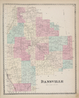
Dansville [Township]
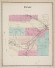
Erwin [Township]
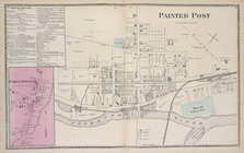
Painted Post Business Notices…
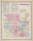
Greenwood Business Notices; G…
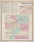
Hartsville Business Notices; …
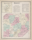
Hornby Forks [Village]; Hornb…
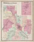
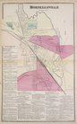
Hornellsville [Township]; Ark…
Hornellsville [Village]; Horn…