Click to visit the main New York Public Library Homepage
The New York Public Library
Digital Collections
About Digital Collections
Browse
Search only public domain materials
Items
Collections
Divisions
Home
Search
Browse
About
Search only public domain materials
Items
Collections
Divisions
Digital Collections
Using Images
Using Data
Search
Filtered keyword search
Show filters
Hide filters
Show Only Public Domain
topic
Population
37
name
x
New York (N.Y.). City Planning Commission
Hospital Council of Greater New York
37
New York (N.Y.). Department of City Planning
37
collection
Atlases of New York City
37
place
New York (N.Y.)
37
genre
Maps
35
Atlases
2
Title pages
1
pages (components)
1
division
x
Map Division
type
x
text
cartographic
35
Date Range
to
37 results found for:
x
map
Filtering on:
x
Division
: Map Division
x
Name
: New York (N.Y.). City Planning Commission
x
Type
: text
Sort by:
Relevance
Title
Date created
Date digitized
Sequence
m
Map
10 - Queens
m
Map
19 - Queens
m
Map
15 - Queens
m
Map
22 - Brooklyn
m
Map
25 - Queens
m
Map
4 - Bronx
m
Map
5 - Manhattan
m
Map
14 - Queens
m
Map
21 - Richmond
m
Map
23 - Brooklyn
m
Map
31 - Queens
m
Map
33 - Richmond
m
Map
28 - Brooklyn
m
Map
34 - Richmond
m
Map
35 - Richmond
m
Map
32 - Richmond
m
Map
3 - Manhattan and Bronx
m
Map
6 - Manhattan, Bronx, and Queens
m
Map
8 - Manhattan, Brooklyn, and Queens
m
Map
11 - Queens
m
Map
12 - Manhattan and Brooklyn
m
Map
17 - Queens and Brooklyn
m
Map
18 - Brooklyn and Queens
m
Map
24 - Brooklyn and Queens
m
Map
27 - Richmond
m
Map
1 - Manhattan and Bronx
m
Map
9 - Manhattan, Brooklyn, and Queens
m
Map
2 - Bronx
m
Map
7 - Bronx and Queens
m
Map
13 - Brooklyn and Queens
m
Map
20 - Richmond
m
Map
16 - Manhattan and Brooklyn
m
Map
26 - Richmond
m
Map
29 - Brooklyn and Queens
m
Map
30 - Brooklyn and Queens
Sectional
map
of the City of New York
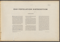
1940 population distribution:…
collection:
Sectional
map
of the City of New York
End of results
|
Top