Click to visit the main New York Public Library Homepage
The New York Public Library
Digital Collections
About Digital Collections
Browse
Search only public domain materials
Items
Collections
Divisions
Home
Search
Browse
About
Search only public domain materials
Items
Collections
Divisions
Digital Collections
Using Images
Using Data
Search
Filtered keyword search
Show filters
Hide filters
Show Only Public Domain
topic
x
Insurance, Fire
Maps
38
name
Perris, William
38
collection
Atlases of New York City
38
place
x
Brooklyn (New York, N.Y.)
genre
Maps
38
Title pages
2
publisher
William Perris
38
division
x
Map Division
type
cartographic
38
text
2
Date Range
to
38 results found for:
x
map
Filtering on:
x
Division
: Map Division
x
Place
: Brooklyn (New York, N.Y.)
x
Topic
: Insurance, Fire
Sort by:
Relevance
Title
Date created
Date digitized
Sequence
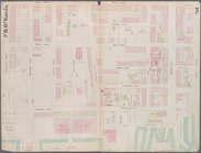
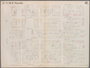
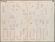
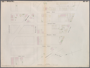
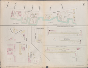
Plate 3:
Map
bounded by East River
topic:
Maps
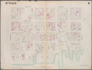
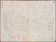
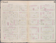
Plate 4:
Map
bounded by East River
topic:
Maps
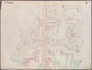
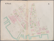
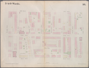
Plate 5:
Map
bounded by East River
topic:
Maps
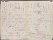
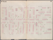
Plate 6:
Map
bounded by Poplar Street
topic:
Maps
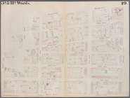
Plate 7:
Map
bounded by Pierrepont
topic:
Maps
Plate 8:
Map
bounded by Pacific Street
topic:
Maps
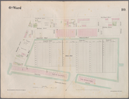
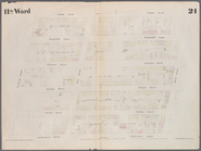
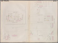
Plate 10:
Map
bounded by Hamilton Avenue
topic:
Maps
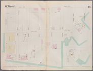
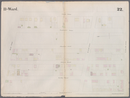
Plate 11:
Map
bounded by Buttermilk
topic:
Maps
Plate 12:
Map
bounded by York Street
topic:
Maps
Plate 13:
Map
bounded by Concord Street
topic:
Maps
Plate 16:
Map
bounded by Montague Street
topic:
Maps
Plate 17:
Map
bounded by Atlantic Street
topic:
Maps
Plate 18:
Map
bounded by Degraw Street
topic:
Maps
Plate 19:
Map
bounded by Concord Street
topic:
Maps
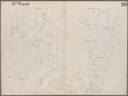
Plate 21:
Map
bounded by Flushing Avenue
topic:
Maps
Plate 22:
Map
bounded by Myrtle Avenue
topic:
Maps
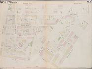
Plate 23:
Map
bounded by Lafayette
topic:
Maps
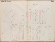
Plate 24:
Map
bounded by Myrtle Avenue
topic:
Maps
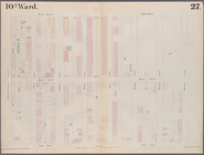
Plate 27:
Map
bounded by Schermerhorn
topic:
Maps
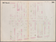
Plate 30:
Map
bounded by Bergen Steet
topic:
Maps
Plate 31:
Map
bounded by Warren Street
topic:
Maps
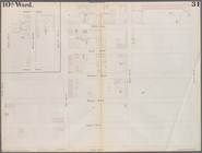
Plate 32:
Map
bounded by Degraw Street
topic:
Maps
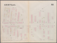
Plate 35:
Map
bounded by William Street
topic:
Maps
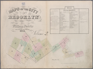
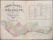
Maps
of the City of Brooklyn
topic:
Maps
Maps
of the City of Brooklyn
topic:
Maps
Plate 9:
Map
bounded by Buttermilk
topic:
Maps
Plate 14:
Map
bounded by Market, James
topic:
Maps
Plate 15:
Map
bounded by Pineapple
topic:
Maps
Plate 20:
Map
bounded by Flushing Avenue
topic:
Maps
Plate 25:
Map
bounded by Willoughby
topic:
Maps
Plate 26:
Map
bounded by Schermerhorn
topic:
Maps
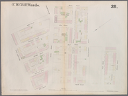
Plate 28:
Map
bounded by Willoughby
topic:
Maps
Plate 29:
Map
bounded by Joralemon
topic:
Maps
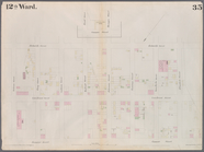
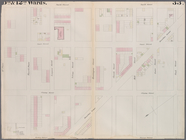
Plate 33:
Map
bounded by Third Place
topic:
Maps
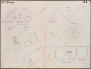
Plate 34:
Map
bounded by Carroll Street
topic:
Maps
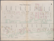
Plate 1:
Map
bounded by North 12th
topic:
Maps
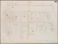
Plate 36:
Maps
Covering Various Areas
topic:
Maps
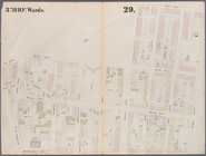
Plate 2:
Map
bounded by South 8th
topic:
Maps
End of results
|
Top