Click to visit the main New York Public Library Homepage
The New York Public Library
Digital Collections
About Digital Collections
Browse
Search only public domain materials
Items
Collections
Divisions
Home
Search
Browse
About
Search only public domain materials
Items
Collections
Divisions
Digital Collections
Using Images
Using Data
Search
Filtered keyword search
Show filters
Hide filters
Show Only Public Domain
topic
x
Atlases, British
Coasts
7
West Indies, British
2
name
Godbid, Anne
7
Playford, John, ca. 1655-1685 or 6
7
Seller, John, fl. 1658-1698
7
collection
x
Lawrence H. Slaughter Collection of English maps, charts, globes, books and atlases
place
Early works to 1800
3
Maps
3
Atlantic Coast (North America)
2
Caribbean Area
2
Mexico, Gulf of
2
More
Less
genre
Maps
7
publisher
x
Printed by A. Godbid and J. Playford, for John Seller ...,
division
x
Map Division
type
cartographic
4
still image
3
Date Range
to
7 results found for:
x
map
Filtering on:
x
Division
: Map Division
x
Publisher
: Printed by A. Godbid and J. Playford, for John Seller ...,
x
Collection
: 6a373d50-c5d3-012f-a6fb-58d385a7bc34
x
Topic
: Atlases, British
Sort by:
Relevance
Title
Date created
Date digitized
Sequence
A
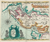
map
of New Iarsey
note:
… to Early
Maps
of the Middle
m
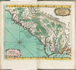
A chart of the West Indias fr…
note:
… to Early
Maps
of the Middle
Carolina newly discribed
note:
… to Early
Maps
of the Middle
m
A chart of the West Indias fr…
note:
… to Early
Maps
of the Middle
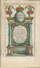
Title page
note:
… to Early
Maps
of the Middle
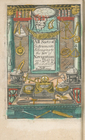
Frontispiece
note:
… to Early
Maps
of the Middle
A mapp of the world
image:
ps_
map
_173