Click to visit the main New York Public Library Homepage
The New York Public Library
Digital Collections
About Digital Collections
Browse
Search only public domain materials
Items
Collections
Divisions
Home
Search
Browse
About
Search only public domain materials
Items
Collections
Divisions
Digital Collections
Using Images
Using Data
Search
Filtered search
Show filters
Hide filters
Show Only Public Domain
name
Sauthier, Claude Joseph
3
Holland, Samuel, 1728-1801
1
Homann Erben (Firm)
1
Jefferys, Thomas, -1771
1
Sayer, Robert, 1725-1794
1
More
Less
collection
Lawrence H. Slaughter Collection of English maps, charts, globes, books and atlases
3
Maps of North America
2
place
x
New Jersey -- Administrative and political divisions -- Maps -- Early works to 1800
New Jersey -- Maps -- Early works to 1800
5
New York (State) -- Administrative and political divisions -- Maps -- Early works to 1800
3
New York (State) -- Maps -- Early works to 1800
3
Northeastern States -- Maps -- Early works to 1800
3
More
Less
genre
Maps
5
Prints
1
publisher
Chez Le Rouge, Ingr. Geographe du Roi ..
1
M. A. Lotter
1
Printed by F. and R. Bailey,
1
Printed for Robt. Sayer ... and T. Jefferys
1
Sumtibus Homannianor. Heredum,
1
division
x
Map Division
type
cartographic
5
Date Range
to
5 results found
Filtering on:
x
Division
: Map Division
x
Place
: New Jersey -- Administrative and political divisions -- Maps -- Early works to 1800
Sort by:
Title
Date created
Date digitized
Sequence
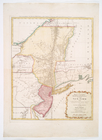
Mappa geographica Provinciae …
Carte des troubles de l'Améri…
m
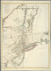
A map of the provinces of New…
New Jersey.
m
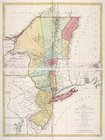
The provinces of New York, an…