Click to visit the main New York Public Library Homepage
The New York Public Library
Digital Collections
About Digital Collections
Browse
Search only public domain materials
Items
Collections
Divisions
Home
Search
Browse
About
Search only public domain materials
Items
Collections
Divisions
Digital Collections
Using Images
Using Data
Search
Filtered keyword search
Show filters
Hide filters
Show Only Public Domain
topic
Real property
47
Nautical charts
20
Administrative and political divisions
13
Railroads
11
Harbors
7
More
Less
name
Beers, F. W. (Frederick W.)
30
Cramer, Louis H
28
United States Coast Survey
19
Bache, A. D. (Alexander Dallas), 1806-1867
18
G.W. & C.B. Colton & Co
9
More
Less
collection
Maps of North America
52
Atlases of the United States
35
Maps of New York City and State
17
Lawrence H. Slaughter Collection of English maps, charts, globes, books and atlases
10
Atlases of New York City
1
place
New York (State)
52
Massachusetts
9
New Jersey
8
Pennsylvania
7
United States
6
More
Less
genre
Maps
113
Atlases
35
Nautical charts
13
Cadastral maps
9
Bathymetric maps
4
More
Less
publisher
J.B. Beers
28
U.S. Coast Survey
11
G.W. & C.B. Colton & Co
7
F. W. Beers & Co
5
U.S. Coast Survey Office
5
More
Less
division
x
Map Division
type
x
cartographic
still image
4
Date Range
to
115 results found for:
x
J. H. B
Filtering on:
x
Division
: Map Division
x
Type
: cartographic
Sort by:
Relevance
Title
Date created
Date digitized
Sequence
Plan of Lovejoy's narrows fro…
parent:
acea7850-
b
143-0132-c36f-58d385a7bbd0
Map of the city of Savannah, …
parent:
0c79e7e0-2
b
8c-0136-ef56-63da78af51cd
Map of Massabesic Lake and su…
parent:
48983f10-
b
144-0132-e269-58d385a7bbd0
Preliminary chart of the sea …
parent:
0
b
61aca0-d632-0132-f6cd-58d385a7
b
928
…
H
, E. 18th St
parent:
03e11930-0aa0-0132-
b
3da-58d385a7bbd0
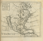
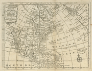
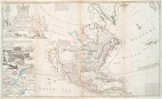
North America : according to …
note:
Lawrence
H
. Slaughter Collection ; 3043.
Map of the states of Ohio Ind…
parent:
f58affb0-c52a-012f-56dd-3c075448cc4
b
Sketch of the triangulation o…
first:
c0f09100-8af4-0133-7a7
b
-00505686a51c
Reconnaissance of Smith's or …
parent:
d137
b
0e0-13f6-0136-383d-5de4d29ce4af
Map of the city of Buffalo
parent:
b
6
b
910
b
0-0bd0-0134-7038-00505686a51c
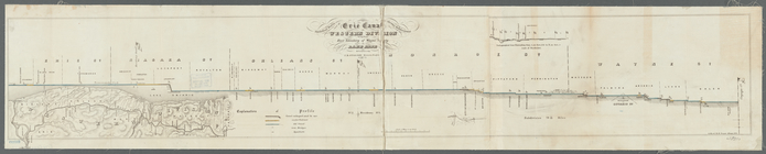
Statistical profile of Erie C…
parent:
3f8241f0-8
b
02-0133-3197-00505686a51c
An accurate map of North Amer…
parent:
6a5739c0-c5d4-012f-7f0
b
-58d385a7bc34
Preliminary chart of Gloucest…
parent:
bac116a0-
b
143-0132-83cb-58d385a7bbd0
Map of wagon routes in Utah T…
parent:
d802d9f0-
b
144-0132-592c-58d385a7bbd0
Preliminary chart of Waccasas…
parent:
af48
b
0e0-16ff-0135-3cde-2
b
19389ea129
Map of New Orleans and Jeffer…
parent:
a533ff30-221e-0135-88ea-23
b
2c52748ca
Montana, Helena special map
parent:
17603
b
30-2930-0136-4517-77871d97e33e
Map of the village of Taunton…
parent:
bac116a0-
b
143-0132-83cb-58d385a7bbd0
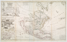
This map of North America acc…
note:
Herman Moll, geographer ;
B
. Lens delin
This map of North America acc…
parent:
64d8c240-c5d5-012f-6
b
0e-58d385a7bc34
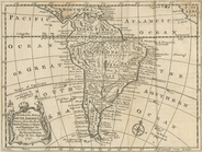
An accurate map of South Amer…
parent:
6ad2def0-c5d4-012f-a7
b
9-58d385a7bc34
Map no. 1 of the El Paso & Fo…
parent:
0781d390-f57c-0135-556
b
-1d53a910dab3
Topographical map in ten-foot…
parent:
69bfffd0-c52
b
-012f-6
b
53-3c075448cc4
b
Preliminary survey of Humbold…
parent:
a5e008f0-0
b
7
b
-0136-2673-7f48acd46977
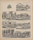
… Stock Farm.
H
. C. and
J
parent:
c8
b
8d7c0-c5f7-012f-da3e-58d385a7bc34
Map of the country thirty thr…
note:
…:
B
. McDonald.
A map of the most inhabited p…
note:
…. 1966. p. [14], [1755?
b
]
A map of the City of Worcester
parent:
b
8713690-6bbd-0134-
b
09f-00505686a51c
North America west coast, Har…
parent:
267c9660-3221-0133-0f42-58d385a7
b
928
Patapsco River and the approa…
parent:
3231
b
290-5e70-0135-a200-2bb85970eb5a
Preliminary chart of entrance…
parent:
45447440-13db-0135-66
b
3-6dae2d7fd847
United States of America
parent:
e21406f0-c52a-012f-655
b
-3c075448cc4
b
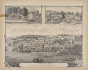
Ervin
H
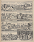
. Ewell. ; Residence of
J
. C. Greene, M
parent:
b
1
b
976c0-c5f7-012f-923a-58d385a7bc34
Berkeley County, Virginia
parent:
2d152130-
b
145-0132-3d42-58d385a7bbd0
Boston Harbor, Massachusetts
parent:
bac116a0-
b
143-0132-83cb-58d385a7bbd0
m
United States of America, 1834
parent:
dc6882
b
0-c52a-012f-f8ea-3c075448cc4
b
State of New-York for Spaffor…
parent:
6ebd9820-c5d3-012f-e2
b
2-58d385a7bc34
Middle part of Long Island So…
first:
99386140-91a1-0135-109d-6
b
28c3143f35
m
New map of St. Lawrence Count…
parent:
f30141
b
0-d592-0132-0499-58d385a7
b
928
Coast chart no. 10 Cape Cod B…
parent:
1c631620-5
b
2a-0134-d939-00505686a51c
m
Map of Cambria Co., Pennsylva…
parent:
69bfffd0-c52
b
-012f-6
b
53-3c075448cc4
b
…. of the Family of the Late L.
H
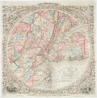
Map of Jersey City, Hoboken &…
parent:
6026d090-c52
b
-012f-3261-3c075448cc4
b
Preliminary chart of Bass Riv…
parent:
ad3ce6c0-529
b
-0134-643a-00505686a51c
Map of the head waters of the…
parent:
ff3ad580-
b
954-0133-04a6-00505686d14e
…., Cheektowaga, N.Y. ; Res. of
J
.
H
. Tyler
… ; Residence of
J
. Mc. Beth, M. …
parent:
d0255
b
50-c5f7-012f-6eba-58d385a7bc34
Tidal currents of Long Island…
note:
…"(
B
. no. 2), U.S. Coast Survey, A. D
m
Map of Clearfield Co., Pennsy…
parent:
69bfffd0-c52
b
-012f-6
b
53-3c075448cc4
b
Boston Harbor, Massachusetts:…
parent:
9
b
408420-8f40-0134-1e9f-00505686a51c