Click to visit the main New York Public Library Homepage
The New York Public Library
Digital Collections
About Digital Collections
Browse
Search only public domain materials
Items
Collections
Divisions
Home
Search
Browse
About
Search only public domain materials
Items
Collections
Divisions
Digital Collections
Using Images
Using Data
Search
Filtered keyword search
Show filters
Hide filters
Show Only Public Domain
topic
Real property
22
Administrative and political divisions
4
Nautical charts
4
Fire insurance
3
History
3
More
Less
name
G.W. Bromley & Co
13
Hooker, William
6
Beers, F. W. (Frederick W.)
4
Anville, Jean Baptiste Bourguignon d', 1697-1782
2
Bache, A. D. (Alexander Dallas), 1806-1867
2
More
Less
collection
Atlases of New York City
16
Maps of New York City and State
11
Maps of North America
11
Atlases of the United States
9
Lawrence H. Slaughter Collection of English maps, charts, globes, books and atlases
2
place
New York (State)
25
Manhattan (New York, N.Y.)
18
New York
14
New York (N.Y.)
9
Louisiana
3
More
Less
genre
Maps
47
Atlases
9
Nautical charts
3
Bathymetric maps
2
Prints
2
More
Less
publisher
G.W. Bromley & Co
13
W. Hooker
4
Andreas, Baskin & Burr
2
W. Hooker,
2
William Perris
2
More
Less
division
x
Map Division
type
cartographic
49
text
5
Date Range
to
49 results found for:
x
Banks%2C W
Filtering on:
x
Division
: Map Division
Sort by:
Relevance
Title
Date created
Date digitized
Sequence
Coast chart from Cape Hattera…
note:
engraved & printed by
W
. Hooker, No. 202
Profiles of enemy's works, Po…
note:
Scale not given (
W
91°24ʹ00ʺ--
W
91°18ʹ10ʺ/N
Map accompanying the report o…
note:
Scale 1:9,200. (
W
73°56ʹ23ʺ--
W
73°54ʹ34ʺ/N
Preliminary chart of Ship Isl…
note:
…. Yeager & App. S.
W
m
Map of the city of Albany
note:
… of Geo.
W
. Carpenter Esqr
Map no. 12, Port Hudson and v…
note:
Scale approximately 1:15,750 (
W
91°24ʹ00ʺ--
W
…. ; Residence of L. A.
Banks
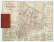
Hooker's new pocket plan of t…
note:
… by
W
. Hooker
Hooker's new pocket plan of t…
note:
… by
W
. Hooker, wholesale
Hooker's new pocket plan of t…
note:
… by
W
. Hooker
m
Hooker's new pocket plan of t…
note:
… by
W
. Hooker, wholesale
Hooker's new pocket plan of t…
note:
… by
W
. Hooker
Hooker's new pocket plan of t…
note:
… by
W
. Hooker
…., long. 72º15{167}
W
note:
…. States & Bahamas
Banks
m
A map of Cabotia: comprehendi…
note:
Scale approximately 1:1,500,000 (
W
87°30ʹ00ʺ--
W
North America performed under…
note:
… by R.
W
. Seale
North America
note:
… by R.
W
. Seale
Bounded by
W
. 14th
…; Residence of
W
. H. Keetch
m
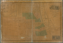
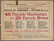
Executors' Sale. Estate of Jo…
note:
…, Boulevard,
W
20th St
…,
Bank
Street, Whitestone
… National
Bank
, Plattsburg
note:
by and under the direction of F.
W
. Beers
…
Bank
. Newburgh, N.Y
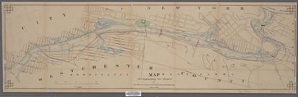
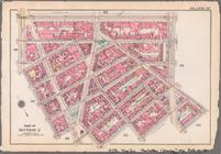
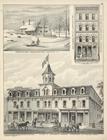
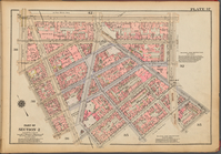
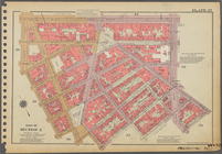
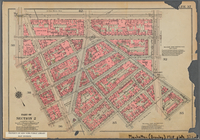
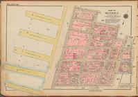
Plate 37, Part of Section 2: …
Plate 37: [Bounded by W. 14th…
collection:
… of New York / G.
W
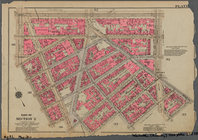
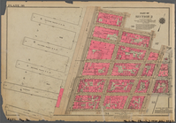
Plate 37, Part of Section 2: …
Bounded by
W
. 14th
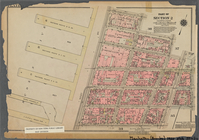
Plate 37, Part of Section 2: …
Bounded by
W
. 14th
… and
Bank
Street
note:
… to 1 inch. (
W
74°00ʹ22ʺ--
W
74°00ʹ20ʺ/N 40°44ʹ…
… to Fulton Sts. ; A. &
W
. Orr
…, N.Y.; T.
W
. Whitney
topic:
Banks
….,
W
. 12th St., 6th Ave.,
W
. 4th St., Perry St.]
…., Orawaupum Ave.,
Bank
St
collection:
… and official plans. By G.
W
. and
W
. S. Bromley
…., Fisher Ave.,
Bank
St.]
collection:
… and official plans. By G.
W
. and
W
. S. Bromley
….]; Manufactorers
Bank
.
Map of Hudson & Manhattan Rai…
note:
Scale approximately 1:30,500 (
W
74°06ʹ34ʺ--
W
Traver's map of Tacoma and en…
note:
… & center : Geo.
W
. Traver
Map bounded by
Bank
Street, Bleecker Street
…, Hudson Street,
Bank
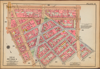
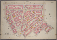
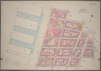
Plate 36, Part of Section 2: …
Plate 36, Part of Section 2: …
…,
W
. 12th Street
…,
W
. 12th Street
… by Shell
Bank
Creek, Hog
collection:
…, Bragg Ave., Avenue
W
Preliminary chart of Stellwagen's
Bank
note:
…"Engg by App. S.
W
. Bradley" -- lower right
… on the left
bank
note:
… by F.
W
. Dorr & C
Plan and section of the north…
note:
J.
W
. Gunnison, U.S. agent & Eng'r
Plat of a survey of land "for…
note:
Scale approximately 1:2,500 (
W
84°21ʹ/N 46°30ʹ).
End of results
|
Top