Click to visit the main New York Public Library Homepage
The New York Public Library
Digital Collections
About Digital Collections
Browse
Search only public domain materials
Items
Collections
Divisions
Home
Search
Browse
About
Search only public domain materials
Items
Collections
Divisions
Digital Collections
Using Images
Using Data
Search
Filtered keyword search
Show filters
Hide filters
Show Only Public Domain
topic
Real property
66
Business enterprises
42
Landowners
34
Administrative and political divisions
6
Cities and towns
5
More
Less
name
Worley & Bracher
78
Bourquin, F. (Frederick), 1808-
63
D.G. Beers & Co
47
Warner & Foote
17
Beers, D. G. (Daniel G.)
11
More
Less
collection
Atlases of the United States
41
Maps of North America
36
Maps of New York City and State
1
place
New York (State)
42
Columbia County
41
Columbia County (N.Y.)
41
Pennsylvania
9
Iowa
8
More
Less
genre
Maps
72
Atlases
41
Cadastral maps
29
Topographic maps
2
Charts
1
More
Less
publisher
D. G. Beers & Co
41
Published by Warner & Foote
12
D.G. Beers & Co
6
Warner & Foote
5
Beers & Lanagan
3
More
Less
division
x
Map Division
type
cartographic
72
text
7
still image
1
Date Range
to
78 results found for:
x
WORLEY
Filtering on:
x
Division
: Map Division
Sort by:
Relevance
Title
Date created
Date digitized
Sequence
m
Map of O'Brian County, Iowa :…
note:
Eng. by
Worley
& Bracher.
m
Map of Monona County, Iowa : …
note:
Eng. by
Worley
& Bracher.
m
Map of Buena Vista County, Io…
note:
Eng. by
Worley
& Bracher.
m
Map of Adams County, Iowa : d…
note:
Eng. by
Worley
& Bracher.
m
Map of Cherokee County, Iowa …
note:
Eng. by
Worley
& Bracher.
m
Map of Henry County, Missouri
note:
Eng. by
Worley
& Bracher, 27 So. Sixth St
m
Map of Calhoun County, Iowa :…
note:
Eng. by
Worley
& Bracher.
m
Map of New York and vicinity:…
note:
engraved by
Worley
& Bracher, 320 Chestnut St
m
Map of Carroll County, Iowa :…
note:
Eng. by
Worley
& Bracher.
m
Map of Plymouth County, Iowa …
note:
Eng. by
Worley
& Bracher.
m
Map of Hennepin County, Minne…
note:
…. ; eng. by
Worley
m
Map of Pettis County, Missour…
note:
Eng. by
Worley
& Bracher.
Map of Rochester, Olmsted Co.…
note:
Eng. by
Worley
& Bracher, 27 So. Sixth St
m
Map of Cass County, Missouri
note:
Eng. by
Worley
& Bracher, 27 So. Sixth St
m
Map of Johnson County, Missou…
note:
Eng. by
Worley
& Bracher, 27 So. Sixth St
m
Map of Bates County, Missouri
note:
Eng. by
Worley
& Bracher, 27 So. Sixth St
m
Map of Goodhue County, Minnes…
note:
Eng. by
Worley
& Bracher.
Topographical map of Fairmoun…
note:
Engraved by
Worley
& Bracher, 320 Chestnut St
m
Map of Haywood County, Tenn. …
note:
…., Philadelphia ; engd by
Worley
m
Map of the city of Boston and…
note:
…. ; engd. by
Worley
m
Map of Garrard and Lincoln co…
note:
…. Lanagan ; eng'd by
Worley
m
Map of Madison County, Tenn. …
note:
…., Philadelphia ; engd. by
Worley
m
Map of Montgomery County, Ken…
note:
…. Lanagan ; eng'd by
Worley
m
Map of Monroe County, Wiscons…
note:
Engd. by
Worley
& Bracher.
m
Map of Harrison County, Ky. :…
note:
…. Lanagan ; engd. by
Worley
m
Map of Maury Co., Tennessee :…
note:
…. Lanagan ; eng. by
Worley
m
Map of Christian County, Ky. …
note:
…. ; engd. by
Worley
m
Map of Scott Co., Kentucky : …
note:
…. Lanagan ; eng'd by
Worley
m
Map of Marion and Washington …
note:
…. ; eng'd by
Worley
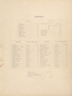
Index
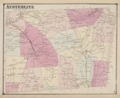
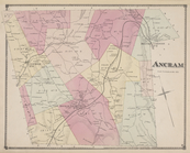
Austerlitz [Township]
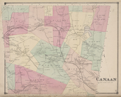
Canaan [Township]
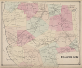
Claverack [Township]
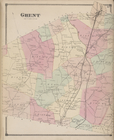
Ghent [Township]
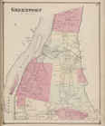
Greenport [Township]
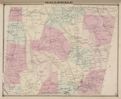
Hillsdale [Township]
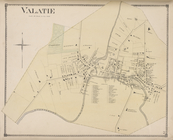
Valatie [Village]
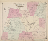
Taghkanic [Township]
Topographical map of Fairmoun…
note:
Engraved by
Worley
& Bracher, 320 Chestnut St
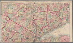
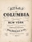
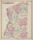
Atlas of Columbia County, New…
Table of Distances
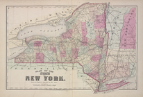
Plan of the State of New York
Columbia Co.
Ancram [Township]
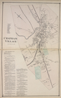
Chatham Village [Village]; Ch…
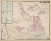
Clermont [Village]; Clermont …
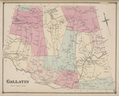
Gallatin [Township]
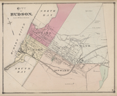
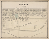
City of Hudson [Township]
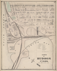
City of Hudson 1st Ward [Town…
City of Hudson West Part of 3…