Click to visit the main New York Public Library Homepage
The New York Public Library
Digital Collections
About Digital Collections
Browse
Search only public domain materials
Items
Collections
Divisions
Home
Search
Browse
About
Search only public domain materials
Items
Collections
Divisions
Digital Collections
Using Images
Using Data
Search
Filtered keyword search
Show filters
Hide filters
Show Only Public Domain
topic
Coasts
1
Enslaved persons
1
Indians of North America
1
Slavery
1
Southern States
1
name
Graham, H. S. (Henry S.)
1
Hergesheimer, E. (Edwin)
1
Leonhardt, Theo. (Theodore), 1818-1877
1
Lynch, William Francis, 1801-1865
1
Smithsonian Institution. Bureau of American Ethnology
1
More
Less
collection
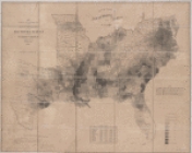
Map showing the distribution of the slave population of the southern states of the United States
1
Republic of Liberia
1
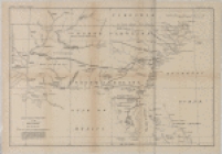
The Distribution of Indian tribes in the Southeast about the year 1715: redrawn from a blueprint of the original among the British Archives
1
place
Liberia
1
Maps
1
genre
x
Maps
publisher
Census Office, Dept. of the Interior?
1
U.S. Senate
1
s.n
1
division
x
Schomburg Jean Blackwell Hutson Research and Reference Division
type
cartographic
3
Date Range
to
3 results found for:
x
Washington (State)
Filtering on:
x
Division
: Schomburg Jean Blackwell Hutson Research and Reference Division
x
Genre
: Maps
Sort by:
Relevance
Title
Date created
Date digitized
Sequence
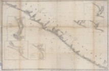
Republic of Liberia
The Distribution of Indian tr…
note:
Photocopy. [
Washington
, D.C. U.S. Govt
…
states
of the United
States