Click to visit the main New York Public Library Homepage
The New York Public Library
Digital Collections
About Digital Collections
Browse
Search only public domain materials
Items
Collections
Divisions
Home
Search
Browse
About
Search only public domain materials
Items
Collections
Divisions
Digital Collections
Using Images
Using Data
Search
Filtered keyword search
Show filters
Hide filters
Show Only Public Domain
topic
Real property
6
Administrative and political divisions
3
Landowners
3
Railroads
1
Streets
1
name
x
J.B. Beers & Co
Beers, F. W. (Frederick W.)
1
Walker & Jewett (Firm)
1
collection
Atlases of the United States
4
Maps of New York City and State
4
Atlases of New York City
1
place
New York (State)
8
Brooklyn (New York, N.Y.)
3
Westchester County
3
Westchester County (N.Y.)
3
New York
2
More
Less
genre
x
Maps
Atlases
4
Cadastral maps
2
publisher
J.B. Beers & Co
3
Published by J.B. Beers & Co
1
Walker & Jewett
1
division
Map Division
9
type
cartographic
9
Date Range
to
9 results found for:
x
Saint Anthony (Hennepin County, Minn. : 1855-1872)
Filtering on:
x
Genre
: Maps
x
Name
: J.B. Beers & Co.
Sort by:
Relevance
Title
Date created
Date digitized
Sequence
…
County
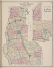
New York; North Part of Cayuga
County
…
County
, New York ; plan of Ulster
County
, New York
note:
Also shows
counties
, cities and towns
m
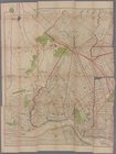
Map of Kings
County
, including the city
m
New map of Kings and Queens
counties
, New York
abstract:
… of Brooklyn (Kings
County
, New
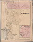
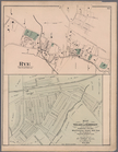
Plate 52: Wakefield, Town &
County
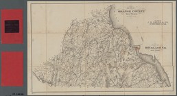
Plan of Orange
County
, New York ; Plan
…
County
. [Back]
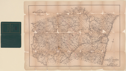
County
atlas of Westchester, New York
…
County
N.Y.