Click to visit the main New York Public Library Homepage
The New York Public Library
Digital Collections
About Digital Collections
Browse
Search only public domain materials
Items
Collections
Divisions
Home
Search
Browse
About
Search only public domain materials
Items
Collections
Divisions
Digital Collections
Using Images
Using Data
Search
Filtered keyword search
Show filters
Hide filters
Show Only Public Domain
topic
Real property
29
Landowners
12
Administrative and political divisions
8
Nautical charts
6
Railroads
6
More
Less
name
Burr, David H., 1803-1875
23
Rawdon, Clark & Co
17
Rawdon, Wright & Co
17
G.W. Bromley & Co
12
De Witt, Simeon, 1756-1834
11
More
Less
collection
Maps of New York City and State
32
Atlases of New York City
28
Atlases of the United States
17
Lawrence H. Slaughter Collection of English maps, charts, globes, books and atlases
3
I. N. Phelps Stokes Collection of American Historical Prints
2
More
Less
place
x
New York (N.Y.)
New York (State)
43
Manhattan (New York, N.Y.)
18
New York
17
New York Metropolitan Area
10
More
Less
genre
x
Maps
Atlases
17
Cadastral maps
3
Views
2
Early works to 1800
1
More
Less
publisher
G.W. Bromley & Co
11
D. H. Burr
6
Stone and Clark,
6
Stone and Clark
5
E. Robinson Co
4
More
Less
division
Map Division
81
Wallach Division: Print Collection
2
Manuscripts and Archives Division
1
type
cartographic
84
text
1
Date Range
to
84 results found for:
x
30
Filtering on:
x
Genre
: Maps
x
Place
: New York (N.Y.)
Sort by:
Relevance
Title
Date created
Date digitized
Sequence
New York and environs : desig…
first:
47c75b
30
-757e-0131-a49d-58d385a7bbd0
New York and environs : desig…
Area Zoning Map Section No.
30
parent:
30593990-bc6a-0132-4f
30
-58d385a7bbd0
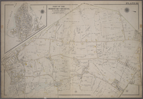
Map of the city of Albany
Bronx, V. A, Plate No.
30
[Map bounded
Bronx, V. B, Plate No.
30
[Map bounded
Plate
30
, Part of Section 2
Double Page Plate No.
30
, Part
Double Page Plate No.
30
, Part
Double Page Plate No.
30
, Part
Use District Map Section No.
30
parent:
30593990-bc6a-0132-4f
30
-58d385a7bbd0
Area District Map Section No.
30
parent:
30593990-bc6a-0132-4f
30
-58d385a7bbd0
Height District Map Section No.
30
parent:
f9925be0-c5fa-012f-fc
30
-58d385a7bc34
Area District Map Section No.
30
parent:
30593990-bc6a-0132-4f
30
-58d385a7bbd0
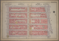
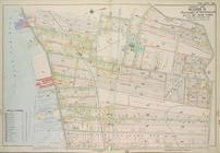
Map of the City of New York
Double Page Plate No.
30
, Part
parent:
789b9c
30
-3071-0132-d134-58d385a7b928
Map of the City of New York w…
m
Map
30
- Brooklyn and Queens
parent:
30593990-bc6a-0132-4f
30
-58d385a7bbd0
Property nos. 43, 45, and 47 …
Map of New York, Brooklyn, an…
Use District Map Section No.
30
parent:
30593990-bc6a-0132-4f
30
-58d385a7bbd0
Plate
30
: Bounded by Fifth Avenue, E. 97th
Plate
30
[Map bounded by Garrison Ave
Plate
30
[Map bounded by E. 208th St
Plate
30
[Map bounded by Zulette Ave
Height District Map Section No.
30
parent:
30593990-bc6a-0132-4f
30
-58d385a7bbd0
Carta della Nuova Inghilterra…
Map of the city of New-York.
Plate
30
: Bounded by Nassau Road, Broadway
Plate
30
, Part of Section 4: [Bounded by W
Plate
30
, Part of Section 5: [Bounded by E
Plate
30
, Part of Ward 3
The Matthews-Northrup up-to-d…
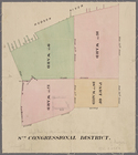
New York City, 8th Congressio…
Use Zoning Map Section No.
30
parent:
30593990-bc6a-0132-4f
30
-58d385a7bbd0
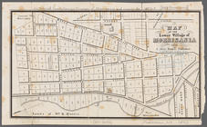
Map of the lower village of M…
m
A map shewing the extent of t…
Plan von New-York, 1851
Plate
30
: Bounded by W. 166th Street
parent:
30593990-bc6a-0132-4f
30
-58d385a7bbd0
Map of the City of New York
note:
… 73°56ʹ
30
ʺ/N 40°46ʹ25ʺ--N
Pocket map of greater New Yor…
Height Zoning Map Section No.
30
parent:
30593990-bc6a-0132-4f
30
-58d385a7bbd0
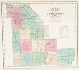
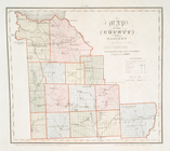
Map of the county of Madison
Map of the county of Madison
Johnson's New York and Brookl…
note:
In right margin:
30
, 31; on verso
Map of New-York and its vicin…
Map of the city of New-York
Map of the city of New-York
Central Park Planning Map No.
30
Map of the city of New-York
parent:
dcacad
30
-c5aa-012f-1843-58d385a7bc34