Click to visit the main New York Public Library Homepage
The New York Public Library
Digital Collections
About Digital Collections
Browse
Search only public domain materials
Items
Collections
Divisions
Home
Search
Browse
About
Search only public domain materials
Items
Collections
Divisions
Digital Collections
Using Images
Using Data
Search
Filtered keyword search
Show filters
Hide filters
Show Only Public Domain
topic
x
Nautical charts
Coasts
5
History
1
name
Des Barres, Joseph F. W. (Joseph Frederick Wallet), 1729-1824
4
Andrews, Peter, fl. 1765-1782
1
Dury, Andrew
1
Fisher, William, active 1677-1704
1
Harris, John, 1667?-1719
1
More
Less
collection
Lawrence H. Slaughter Collection of English maps, charts, globes, books and atlases
7
Maps of North America
3
Maps of New York City and State
1
place
New York (N.Y.)
4
New York (State)
4
New York Harbor (N.Y. and N.J.)
3
Atlantic Coast (North America)
2
Long Island (N.Y.)
2
More
Less
genre
x
Maps
publisher
Published for the use of the Royal Navy of Great Britain by Joseph F. W. Des Barres
2
Heather and Williams
1
Printed and sold by Wm. Herbert under the Piazzas on London Bridge & Robt. Sayer facing Fetter Lane, Fleet Street
1
Printed for Robert Sayer and John Bennett, map & chartsellers at no. 53 in Fleet Street ... ,
1
Printed for William Fisher and John Thornton
1
More
Less
division
Map Division
11
type
cartographic
11
Date Range
to
11 results found for:
x
Middle East
Filtering on:
x
Genre
: Maps
x
Topic
: Nautical charts
Sort by:
Relevance
Title
Date created
Date digitized
Sequence
Virginia, Maryland, Pennsilvania,
east
& west New
note:
… to Early Maps of the
Middle
Virginia, Maryland, Pennsilvania,
east
& west New
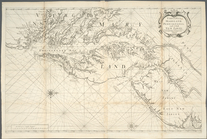
A chart of the Atlantick Ocea…
note:
Covers
east
coast of North America from
m
Oyster Bay and Huntington, Hu…
note:
… to Early Maps of the
Middle
… River,
East
River
note:
… to Early Maps of the
Middle
…,
East
River, passage
note:
… to Early Maps of the
Middle
A sketch of the operations of…
note:
… to Stony Point,
east
as far
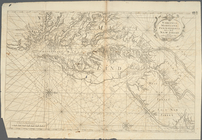
A new chart of America with t…
note:
Nautical chart of the
east
coast of the U.S
An actual survey of the sea c…
note:
Shows longitude
east
and west from
A plan of the city of New-Yor…
note:
… to Early Maps of the
Middle
m
… and north-
east
note:
… on the north-
east
current
End of results
|
Top