Click to visit the main New York Public Library Homepage
The New York Public Library
Digital Collections
About Digital Collections
Browse
Search only public domain materials
Items
Collections
Divisions
Home
Search
Browse
About
Search only public domain materials
Items
Collections
Divisions
Digital Collections
Using Images
Using Data
Search
Filtered keyword search
Show filters
Hide filters
Show Only Public Domain
topic
Administrative and political divisions
11
History
11
Nautical charts
11
Real property
8
Geography
7
More
Less
name
Burr, David H., 1803-1875
10
Hooker, William
9
Moll, Herman, -1732
6
S. Stiles & Co
6
Faden, William, 1749-1836
5
More
Less
collection
Maps of New York City and State
53
Lawrence H. Slaughter Collection of English maps, charts, globes, books and atlases
29
Maps of North America
23
Atlases of the United States
3
John H. Levine Collection
3
More
Less
place
New York (N.Y.)
37
Manhattan (New York, N.Y.) -- Maps
33
New York (N.Y.) -- Maps
32
New York (N.Y.) -- Administrative and political divisions -- Maps
19
New York (State)
17
More
Less
genre
x
Maps
Manuscripts
2
Atlases
1
Guidebooks
1
Pictorial works
1
More
Less
publisher
W. Hooker
4
Printed by James Parker, and a few Copies are to be Sold by him, and Benjamin Franklin, in Philadelphia;
3
... Sold ... by Tho. Bowles, print and map-seller in St. Paul's-Churchyard
2
A. Jombert
2
Printed for Ieames Shawe, and are to be solde at his shoppe nigh Ludgate,
2
More
Less
division
Map Division
113
General Research Division
2
Manuscripts and Archives Division
2
Spencer Collection
1
type
cartographic
118
text
10
still image
3
Date Range
to
118 results found for:
x
Middle East
Filtering on:
x
Genre
: Maps
Sort by:
Relevance
Title
Date created
Date digitized
Sequence
m
Corlears Hook
note:
… Street to the
East
River, and Grand Street to
Middle
… Canal to
east
boundary
Map showing the Southern Mary…
New Hampshire by recent survey
note:
… of the Union
east
of the Hudson
A map of a portion of the Indian country lying
east
Map of the great north west: …
note:
Covers
Middle
West from Omaha
east
A plan of the city of New-Yor…
note:
… to Early Maps of the
Middle
North America from the French…
note:
… to Early Maps of the
Middle
Map of the United States in N…
note:
… in the
East
and West
United States of America
note:
Shows the United States
east
A new chart of America with t…
note:
Nautical chart of the
east
coast of the U.S
… River,
East
River
note:
… to Early Maps of the
Middle
… the Spanish provinces of
east
note:
… to Early Maps of the
Middle
… and
East
Florida from
note:
… to Early Maps of the
Middle
Carte de la Louisiane cours d…
note:
Covers United States
east
of Rio Grande
A new map of New England and …
note:
Covers New England as far north and
east
An exact mapp of New England …
note:
Covers area from the Hudson River Valley
east
m
A new and exact map of the do…
note:
… of Carolina and the
east
part
North America from the French…
note:
… to Early Maps of the
Middle
Map no. I : [to accompany A b…
note:
A presentation of the case of the
East
Jersey
Map no. II : [to accompany A …
note:
A presentation of the case of the
East
Jersey
Map no. III : [to accompany A…
note:
A presentation of the case of the
East
Jersey
Virginia, Maryland, Pennsilvania,
east
& west New
note:
… to Early Maps of the
Middle
Nova Anglia, Novum Belgium, e…
note:
Covers the
east
coast of North America
Virginia, Maryland, Pennsilvania,
east
& west New
A chart of the Atlantick Ocea…
note:
Covers
east
coast of North America from
…,
East
River, passage
note:
… to Early Maps of the
Middle
m
The isle of California, New M…
note:
… not cover
East
Coast.
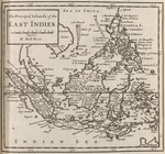
The principal islands of the
East
Indies.
note:
… to Early Maps of the
Middle
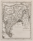
East
India.
note:
… to Early Maps of the
Middle
… the Spanish provinces of
East
note:
… to Early Maps of the
Middle
A map of the
East
and West Florida.
note:
… to Early Maps of the
Middle
A map of the
East
-Indies and the adjacent
note:
… to Early Maps of the
Middle
Westfalia.
note:
… to Early Maps of the
Middle
India Orient.
note:
… to Early Maps of the
Middle
The course of the River St. L…
note:
United States map covers area
east
… Street,
east
of 6th
note:
… to Early Maps of the
Middle
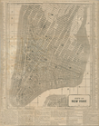
Plan of the city of New-York
note:
…. on the
east
.
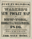
Hooker's new pocket plan of t…
note:
… on the
east
side.
Strangers guide through the c…
note:
…. on the
east
side.
City of New-York
note:
…. on the
east
side. Also covers
Map of the City of New-York w…
note:
…. on the
east
side.
m
Oyster Bay and Huntington, Hu…
note:
… to Early Maps of the
Middle
… &
east
New Jersey
note:
… to Early Maps of the
Middle
Map of the western part of th…
note:
… to the
east
boundary
City of New-York
note:
Covers Manhattan up to
East
40th St
City of New York.
note:
… on
east
side, and a small
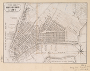
The Great metropolis in 1804.
note:
…. Houston) on the
east
side.
m
Hooker's new pocket plan of t…
note:
… on the
east
side.
… and the
East
River.
note:
… to Early Maps of the
Middle