Click to visit the main New York Public Library Homepage
The New York Public Library
Digital Collections
About Digital Collections
Browse
Search only public domain materials
Items
Collections
Divisions
Home
Search
Browse
About
Search only public domain materials
Items
Collections
Divisions
Digital Collections
Using Images
Using Data
Search
Filtered keyword search
Show filters
Hide filters
Show Only Public Domain
topic
Surveys
3
Coal
2
Geology
2
Indian reservations
2
Soil surveys
2
More
Less
name
x
Julius Bien & Co
Bien, Julius, 1826-1909
15
Vermeule, C. C. (Cornelius Clarkson), 1858-1950
15
Northern Transcontinental Survey
8
Pumpelly, Raphael, 1837-1923
7
More
Less
collection
Maps of North America
17
Atlases of the United States
15
place
New York (N.Y.)
15
New York Metropolitan Area
15
Washington (State)
6
Yakima River Valley (Wash.)
4
Yakima River Valley
3
More
Less
genre
x
Topographic maps
Maps
32
Atlases
15
Diagrams
1
Geological cross-sections
1
More
Less
publisher
Julius Bien & Co
15
Northern Transcontinental Survey?
6
Benjamin Smith Lyman?
2
Northern Transcontinental Survey
2
Bureau of American Ethnology
1
More
Less
division
Map Division
32
type
cartographic
32
text
2
Date Range
to
32 results found for:
x
map
Filtering on:
x
Genre
: Topographic maps
x
Name
: Julius Bien & Co.
Sort by:
Relevance
Title
Date created
Date digitized
Sequence
Map
of Colville Region, Washington Ter. …
note:
NYPL
Map
Div. copy
Detailed
map
of part of Canyon De
note:
NYPL
Map
Div. copy has accession no
A geological and topographical sketch
map
note:
… catalog of the
Map
Map
of Crazy Mountains and vicinity
note:
NYPL
Map
Div. copy imperfect: large segment
Map
of Yakima Region, Washington Ter. …
note:
NYPL
Map
Div. copy
A geological and topographical rough survey
map
note:
… catalog of the
Map
Preliminary agricultural
map
of Colville
note:
… catalog of the
Map
A geological and topographical sketch
map
note:
Mapping
the Nation (NEH grant, 2015-2018)…
Topographical
map
of the District of Columbia
note:
Partial cadastral
map
showing landowners
m
United States
note:
Mapping
the Nation (NEH grant, 2015-2018)…
m
Map
of Judith Basin, Montana Ter. …
note:
… catalog of the
Map
Map
of Yakima Region, Washington Ter. …
note:
… catalog of the
Map
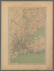
New Haven, Connecticut
note:
Mapping
the Nation (NEH grant, 2015-2018)…
m
Massachusetts
note:
…"Compiled from the original sheets of a
map
Forest
map
of the Yakima Region, Washington
note:
… catalog of the
Map
Plate No. 1: Index Map
collection:
… in a series of
maps
m
Preliminary agricultural
map
of Yakima
note:
… catalog of the
Map
Topographical
map
in ten-foot contour
note:
Mapping
the Nation (NEH grant, 2015-2018)…
m
Double Page Plate No. 12: Wes…
collection:
… in a series of
maps
m
Double Page Plate No. 5: Rich…
collection:
… in a series of
maps
m
Double Page Plate No. 13: Wes…
collection:
… in a series of
maps
m
Double Page Plate No. 6: Newa…
collection:
… in a series of
maps
m
Double Page Plate No. 2: City…
collection:
… in a series of
maps
m
Double Page Plate No. 11: Wes…
collection:
… in a series of
maps
m
Double Page Plate No. 7: Newa…
collection:
… in a series of
maps
m
Double Page Plate No. 8: Long…
collection:
… in a series of
maps
m
Double Page Plate No. 3: Broo…
collection:
… in a series of
maps
m
Double Page Plate No. 10: Wes…
collection:
… in a series of
maps
m
Double Page Plate No. 9: West…
collection:
… in a series of
maps
m
Double Page Plate No. 4: The …
collection:
… in a series of
maps
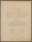
List of Plates and References
collection:
… in a series of
maps
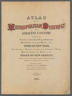
Atlas of the Metropolitan Dis…
collection:
… in a series of
maps
End of results
|
Top