Click to visit the main New York Public Library Homepage
The New York Public Library
Digital Collections
About Digital Collections
Browse
Search only public domain materials
Items
Collections
Divisions
Home
Search
Browse
About
Search only public domain materials
Items
Collections
Divisions
Digital Collections
Using Images
Using Data
Search
Filtered keyword search
Show filters
Hide filters
Show Only Public Domain
topic
Railroads
4
Altitudes
3
Streets
3
Landowners
2
Parks
2
More
Less
name
Geological Survey (U.S.)
4
Welcke, Robert A
4
Guyot, A. (Arnold), 1807-1884
3
Sandoz, Ernest
3
Schedler, J. (Joseph)
3
More
Less
collection
x
Maps of New York City and State
place
New York (State)
23
New York
9
Bronx (New York, N.Y.)
5
New York (N.Y.)
5
New York Metropolitan Area
5
More
Less
genre
x
Topographic maps
Maps
28
Cadastral maps
4
publisher
C. Scribner's Sons
3
Topographical Bureau
3
U.S. Geological Survey
3
Aqueduct Commission?
2
Board of Public Improvements, Topographical Bureau
2
More
Less
division
Map Division
28
type
cartographic
28
Date Range
to
28 results found for:
x
map
Filtering on:
x
Genre
: Topographic maps
x
Collection
: Maps of New York City and State
For more collection details, visit the
Maps of New York City and State collection page
.
Sort by:
Relevance
Title
Date created
Date digitized
Sequence
m
Map
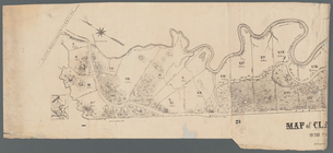
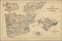
of Clasons Point
note:
Mapping
the Nation (NEH grant, 2015-2018)…
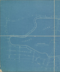
Relief
map
of New York and vicinity
note:
…
map
.
m
Map
or plan showing the proposed changes of lines
m
Topographical
map
m
New York City and vicinity
collection:
Maps
of New York City and State
Map
accompanying the report of the Bureau
Lake Pleasant, - C.H. formerl…
note:
Mapping
the Nation (NEH grant, 2015-2018)…
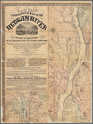
m
Lloyd's topographical
map
of the Hudson
note:
Wall
map
.
Map
showing topographical survey of land
note:
Mapping
the Nation (NEH grant, 2015-2018)…
m
Map
of the Catskill Mountains
note:
Mapping
the Nation (NEH grant, 2015-2018)…
Map
of the Catskill Mountains
note:
Mapping
the Nation (NEH grant, 2015-2018)…
m
Map
of the Catskill Mountains
note:
Mapping
the Nation (NEH grant, 2015-2018)…
m
General
map
of the city of New York
note:
Note mounted on
map
: The original of this
map
m
Asher & Adams' new topographical
map
of the state
note:
Mapping
the Nation (NEH grant, 2015-2018)…
m
New York und Umgegend
collection:
Maps
of New York City and State
Aqueduct Commissioners topographical
map
note:
Mapping
the Nation (NEH grant, 2015-2018)…
Aqueduct Commissioners topographical
map
note:
Mapping
the Nation (NEH grant, 2015-2018)…
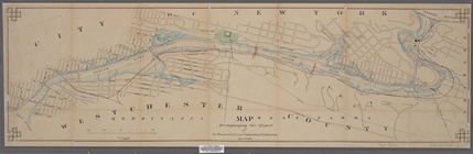
Topographical
map
showing street system
m
Topographical
map
of New York and vicinity …
note:
Insets: Navesink Park --
Map
of Long
Map
or plan showing the street system in the 12th
m
Map
or plan of streets, roads, avenues
Topographical
map
made from surveys
note:
…
map
to 1874.
Map
or plan of section 10 [Crotona Park]
abstract:
… lines. Source:
Maps
Topographical
map
of Seneca County, N.Y.
note:
Mapping
the Nation (NEH grant, 2015-2018)…
A topographical
map
of Lewis Co., New York
note:
Cadastral
map
showing property owners
New York City and environs : …
collection:
Maps
of New York City and State
Albany and vicinity
note:
Mapping
the Nation (NEH grant, 2015-2018)…
Land classification
map
, New York, Mt
note:
Mapping
the Nation (NEH grant, 2015-2018)…
End of results
|
Top