Click to visit the main New York Public Library Homepage
The New York Public Library
Digital Collections
About Digital Collections
Browse
Search only public domain materials
Items
Collections
Divisions
Home
Search
Browse
About
Search only public domain materials
Items
Collections
Divisions
Digital Collections
Using Images
Using Data
Search
Filtered keyword search
Show filters
Hide filters
Show Only Public Domain
topic
Nautical charts
98
Harbors
28
Navigation
15
Coasts
14
Bays
6
More
Less
name
United States Coast Survey
85
Bache, A. D. (Alexander Dallas), 1806-1867
73
Maffitt, John Newland, 1819-1886
19
Boutelle, C. O. (Charles Otis)
13
Mathiot, G
11
More
Less
collection
Maps of North America
110
Maps of New York City and State
3
place
Florida
17
South Carolina
17
Virginia
16
North Carolina
15
Atlantic Ocean
13
More
Less
genre
x
Bathymetric maps
Maps
113
Nautical charts
96
Topographic maps
4
Cadastral maps
1
More
Less
publisher
U.S. Coast Survey
49
U.S. Coast Survey Office
20
United States Coast Survey
9
U.S. Senate?
4
Coast Survey Office
3
More
Less
division
Map Division
113
type
cartographic
113
still image
1
Date Range
to
113 results found for:
x
Washington (State)
Filtering on:
x
Genre
: Bathymetric maps
Sort by:
Relevance
Title
Date created
Date digitized
Sequence
Reconnaissance of Olympia Harbor,
Washington
…,
Washington
Ter. …
m
Flushing Bay, Long Island, N.…
note:
…"United
States
Engineer Office, District
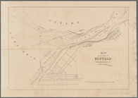
Map of the vicinity of Buffal…
collection:
Maps of New York City and
State
A map of the extremity of Cap…
note:
… Engineers,
Washington
…, Wisconsin,
Washington
Co. …
1889, Larchmont Harbor, N.Y.:…
collection:
Maps of New York City and
State
Military map of south-eastern…
note:
…
states
: Map of the
state
Map of the coast of Massachus…
note:
….
Washington
: [1872?]
Copy of plate of Kenosha harb…
note:
…,
Washington
, July 19, 1854
Reconnaissance of Port Royal …
collection:
States
General chart of Alaska : com…
abstract:
… United
States
and Russian
Preliminary survey of the ent…
collection:
States
Nantucket Sound: western part
collection:
States
Vineyard Sound from Wood's Ho…
collection:
States
The Hawaiian Islands: compile…
note:
….,
Washington
, D.C."--Lower
Preliminary chart of Winyah B…
collection:
States
Preliminary survey of Humbold…
abstract:
… of the United
States
Coast Survey.
Washington
, D.C
Preliminary chart of Beaufort…
collection:
States
Preliminary chart of Hampton …
collection:
States
Hawaiian or Sandwich Islands
collection:
States
Sketch of the coast of North …
collection:
States
Atlantic Coast, Chesapeake en…
collection:
States
Coast chart no. 48, Cape Fear…
collection:
States
Preliminary chart of part of …
note:
…
States
.
Edgartown harbor and Cotamy B…
collection:
States
Chart of a part of the Gulf o…
collection:
States
Reconnaissance of Hatteras In…
collection:
States
Tybee Bay and Calibogue Sound…
collection:
States
Reconnaissance of the entranc…
collection:
States
Ocilla River, Florida
collection:
States
Preliminary chart of Frying P…
note:
…
States
.
Preliminary chart of Calibogu…
collection:
States
Reconnoissance of Cape Canave…
collection:
States
Hydrographic reconnaissance o…
collection:
States
Charleston harbour, S. Ca. : …
collection:
States
Sketch of Ocracoke Inlet, Nor…
collection:
States
Preliminary chart of Hatteras…
note:
…
States
.
Map of comparison of Maffitt'…
collection:
States
m
Map of the portion of the Con…
collection:
United
States
(except New York)…
Preliminary sketch of Cherrys…
collection:
States
St. Helena Sound, South Carol…
collection:
States
Reconnaissance of Doboy Bar a…
collection:
States
Preliminary chart of the sea …
collection:
United
States
(except New York)…
Norfolk harbor, Virginia : fr…
collection:
States
m
Preliminary chart of Port Roy…
note:
…
States
.
Stono Inlet, South Carolina
note:
…
States
.
Preliminary chart of St. Mark…
note:
…
States
.
Preliminary chart of Ossabaw …
note:
…
States
.
Preliminary chart of Bull's B…
collection:
States