Click to visit the main New York Public Library Homepage
The New York Public Library
Digital Collections
About Digital Collections
Browse
Search only public domain materials
Items
Collections
Divisions
Home
Search
Browse
About
Search only public domain materials
Items
Collections
Divisions
Digital Collections
Using Images
Using Data
Search
Filtered keyword search
Show filters
Hide filters
Show Only Public Domain
topic
Real property
20
Fire insurance
3
Bakeries
1
Banks
1
Buildings
1
More
Less
name
G.W. Bromley & Co
13
Perris, William
4
Bromley, George Washington
2
Bromley, Walter Scott
2
Perris & Browne
2
More
Less
collection
Atlases of New York City
17
Atlases of the United States
4
Maps of New York City and State
3
Maps of North America
1
place
x
New York (State)
Manhattan (New York, N.Y.)
17
New York
16
New York (N.Y.)
3
Westchester County
2
More
Less
genre
x
Maps
Atlases
4
Manuscript maps
1
Topographic maps
1
publisher
G.W. Bromley & Co
13
William Perris
2
Perris & Browne
2
E. Belcher Hyde
1
Engraved by American Bank Note Company
1
More
Less
division
Map Division
23
type
cartographic
25
Date Range
to
25 results found for:
x
Banks%2C W
Filtering on:
x
Genre
: Maps
x
Place
: New York (State)
Sort by:
Relevance
Title
Date created
Date digitized
Sequence
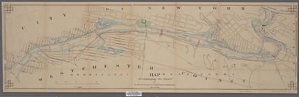
Map accompanying the report o…
note:
Scale 1:9,200. (
W
73°56ʹ23ʺ--
W
73°54ʹ34ʺ/N
…. ; Residence of L. A.
Banks
m
A map of Cabotia: comprehendi…
note:
Scale approximately 1:1,500,000 (
W
87°30ʹ00ʺ--
W
Bounded by
W
. 14th
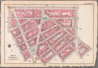
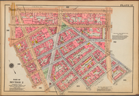
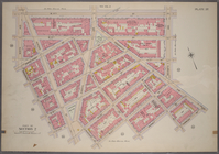
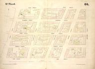
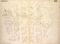
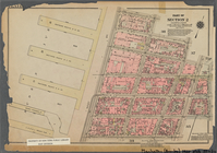
Plate 37, Part of Section 2: …
Plate 37: [Bounded by W. 14th…
collection:
… of New York / G.
W
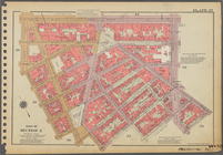
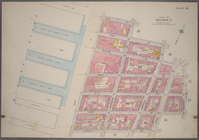
Plate 37, Part of Section 2: …
Bounded by
W
. 14th
Plate 37, Part of Section 2: …
Bounded by
W
. 14th
… and
Bank
Street
note:
… to 1 inch. (
W
74°00ʹ22ʺ--
W
74°00ʹ20ʺ/N 40°44ʹ…
…, N.Y.; T.
W
. Whitney
topic:
Banks
….,
W
. 12th St., 6th Ave.,
W
. 4th St., Perry St.]
…,
Bank
Street, Hudson
collection:
… Street,
Bank
Street
… River,
Bank
Street
…., Orawaupum Ave.,
Bank
St
collection:
… and official plans. By G.
W
. and
W
. S. Bromley
…., Fisher Ave.,
Bank
St.]
collection:
… and official plans. By G.
W
. and
W
. S. Bromley
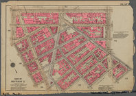
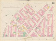
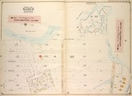
Map of Hudson & Manhattan Rai…
note:
Scale approximately 1:30,500 (
W
74°06ʹ34ʺ--
W
Map bounded by
Bank
Street, Bleecker Street
…, Hudson Street,
Bank
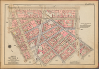
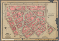
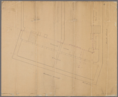
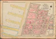
Plate 36, Part of Section 2: …
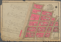
Plate 36, Part of Section 2: …
…,
W
. 12th Street
…,
W
. 12th Street
… by Shell
Bank
Creek, Hog
collection:
…, Bragg Ave., Avenue
W
End of results
|
Top