Click to visit the main New York Public Library Homepage
The New York Public Library
Digital Collections
About Digital Collections
Browse
Search only public domain materials
Items
Collections
Divisions
Home
Search
Browse
About
Search only public domain materials
Items
Collections
Divisions
Digital Collections
Using Images
Using Data
Search
Filtered keyword search
Show filters
Hide filters
Show Only Public Domain
topic
Administrative and political divisions
20
History
12
Landowners
10
Railroads
9
Real property
9
More
Less
name
United States. Post Office Department
7
American Civil War (1861-1865)
6
Beers, D. G. (Daniel G.)
6
Lanagan, J
6
Worley & Bracher
6
More
Less
collection
Maps of North America
57
Atlases of the United States
4
Circulars no. 1-4
4
Atlases, gazetteers, guidebooks and other books
2
Lawrence H. Slaughter Collection of English maps, charts, globes, books and atlases
2
place
Kentucky
46
Tennessee
19
Southern States
12
United States
10
Illinois
8
More
Less
genre
x
Maps
Cadastral maps
6
Geological maps
3
Atlases
2
Diagrams
1
More
Less
publisher
Post Office Department
5
publisher not identified
4
Beers & Lanagan
3
D.G. Beers & Co
3
A.H. Mueller Co.,
2
More
Less
division
Map Division
65
Rare Book Division
4
type
cartographic
69
text
4
Date Range
to
69 results found for:
x
Kentucky
Filtering on:
x
Genre
: Maps
Sort by:
Relevance
Title
Date created
Date digitized
Sequence
Preliminary map of
Kentucky
…
note:
At head of title:
Kentucky
Geological Survey
Preliminary map : compiled fr…
note:
At head of title:
Kentucky
Geological Survey
m
… in
Kentucky
; Township and town
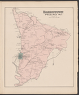
Bardstown, Precinct No.1, Nel…
collection:
An Atlas of Nelson & Spencer cos.,
Kentucky
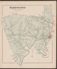
Bardstown, Precinct No. 9, Ne…
collection:
An Atlas of Nelson & Spencer cos.,
Kentucky
Johnson's
Kentucky
and Tennessee
abstract:
… of
Kentucky
and Tennessee
… of
Kentucky
…
m
Map of Garrard and Lincoln counties,
Kentucky
…
m
Map of the states of
Kentucky
and Tennessee …
abstract:
…
Kentucky
and Tennessee
m
Map of Marion and Washington …
collection:
Map of Marion and Washington counties,
Kentucky
… of
Kentucky
…
War map of
Kentucky
… of
Kentucky
…
m
Map of
Kentucky
and Tennessee …
abstract:
… for
Kentucky
and Tennessee.
Map of the states of
Kentucky
, and Tennessee
abstract:
Subject: Map of
Kentucky
and Tennsessee
Townships of Franklin and Som…
collection:
… of the state of
Kentucky
Map of the state of
Kentucky
…
… and the
Kentucky
Central Railway
m
Map of Scott Co.,
Kentucky
…
County map of
Kentucky
and Tennessee …
Kentucky
…
A map of
Kentucky
from actual survey …
m
Map of Montgomery County,
Kentucky
…
Map of
Kentucky
and Tennessee …
Kentucky
…
City of Covington
collection:
Kentucky
m
Map of Harrison County, Ky. :…
collection:
Map of Harrison County,
Kentucky
m
Map of Christian County, Ky. …
collection:
Map of Christian County,
Kentucky
m
Post route map of the states of
Kentucky
m
Post route map of the states of
Kentucky
The Caron map of the city of …
collection:
Kentucky
Kentucky
m
Map of
Kentucky
& Tennessee …
m
Franklinville with privileges…
m
Kentucky
and Tennessee …
Kentucky
et Tennessee …
Western states
note:
Covers
Kentucky
, Ohio, Indiana, Illinois
The town and township, of Ohi…
Mineral territory tributary t…
abstract:
… Boyd County,
Kentucky
Eastern United States, No. 6
abstract:
…, Illinois,
Kentucky
…, and
Kentucky
Map of the western states to …
note:
…,
Kentucky
, and parts of Iowa
Fourteenth l.h. district
Topographical map of lands be…
note:
…,
Kentucky
, 1855.
Map showing the location of t…
collection:
Kentucky
…,
Kentucky
, Pennsylvania
note:
Sames, J.W. Index of
Kentucky
& Virginia maps
Map of Cincinnati and suburbs…
m
Post route map of the states …
collection:
…, Tennessee,
Kentucky
, West
County map of
Kentucky
and Tennessee.
m
Post route map of the states …
collection:
…, Tennessee,
Kentucky
, West