Click to visit the main New York Public Library Homepage
The New York Public Library
Digital Collections
About Digital Collections
Browse
Search only public domain materials
Items
Collections
Divisions
Home
Search
Browse
About
Search only public domain materials
Items
Collections
Divisions
Digital Collections
Using Images
Using Data
Search
Filtered keyword search
Show filters
Hide filters
Show Only Public Domain
topic
Real property
76
Landowners
55
Administrative and political divisions
29
Real propery auctions
13
Fire insurance
12
More
Less
name
Walling, Henry Francis, 1825-1888
44
Sanborn Map Company
11
H.F. Walling's Map Establishment
9
M.I.T. Press
8
New York (N.Y.). City Planning Commission
8
More
Less
collection
Maps of North America
65
Atlases of New York City
39
Maps of New York City and State
26
Bancker plans
19
Collection of broadside real estate maps announcing auctions of lots in early 19th century New York City
13
More
Less
place
New York (State)
69
New York
46
Manhattan (New York, N.Y.)
25
United States
22
New York (N.Y.)
21
More
Less
genre
x
Maps
Cadastral maps
46
Surveys
20
land surveys
18
Wall maps
14
More
Less
publisher
Sanborn Map Company
9
MIT Press
8
publisher not identified
8
H.F. Walling
6
Lith. by Korff Brothers
4
More
Less
division
Map Division
151
Manuscripts and Archives Division
19
Rare Book Division
2
George Arents Collection
1
type
cartographic
164
still image
19
text
2
Date Range
to
175 results found for:
x
Walls
Filtering on:
x
Genre
: Maps
Sort by:
Relevance
Title
Date created
Date digitized
Sequence
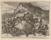
… the
Walls
of Taxamalco.
note:
… the
Walls
of Taxamalco."…
m
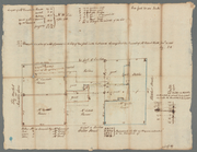
Four lots of ground near the …
note:
For Robert
Walls
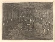
. Fly Market or Maiden
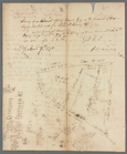
Temple Cell with
Walls
bedaub'd two
note:
…, and the
Walls
bedaub'd two
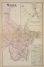
Map of Perry County, Ohio
note:
From surveys under the direction of H. F.
Walling
.
Map of the city of Milwaukee,…
note:
… the direction of H.F.
Walling
m
Map of Essex County, New Jers…
note:
… the direction of H.F.
Walling
m
Wall
Street
note:
Thurman and Dunscomb. Corner of
Wall
m
Wall
Street
note:
… at Smith and
Wall
Street.
Map of Clinton County, Ohio
note:
… the direction of H.F.
Walling
Map of the state of Vermont
note:
… the direction of H.F.
Walling
Map of the county of Plymouth…
note:
… of Henry F.
Walling
, Supt
m
Wall
Street, Plow and Harrow, Indian King
note:
N. Bayard's on
Wall
street, and J. Delancey
m
Lot and house in
Wall
Street near Coffee
note:
For James Rivington.
Wall
Street between
m
Mr. Lawrence Read's house in
Wall
Street
note:
… Street,
Wall
Street
m
Wall
Street, Broad Street to William Street
note:
… bearing of
Wall
Street
m
Topographical map of the Coun…
note:
… at H.F.
Walling
's Map
m
Map of Vigo County, Indiana
note:
… of H.F.
Walling
Map of Massachusetts: compris…
note:
Surveyed, drawn and engraved by H.F.
Walling
.
Map of the town of Blackstone…
note:
by H.F.
Walling
.
m
Map of the town of Norton, Br…
note:
by H.F.
Walling
, supt. of the state map.
Map of the town of Concord, M…
note:
….
Walling
, Civil Engr.
m
Map of the county of Berkshir…
note:
….
Walling
. Supt
Map of the county of Berkshir…
note:
….
Walling
. Supt
m
United States: wall-atlas
collection:
Wall
-atlas
m
Map of the State of Rhode Isl…
Map of the city of Taunton ma…
note:
by H.F.
Walling
& O.W. Gray under
… from
Walling
's large
Wall
[Township
m
Topographical map of the coun…
note:
From surveys under the direction of H.F.
Walling
.
m
Mallet in
Wall
Street
Hempstead
note:
Inset from:
Walling
, H. F. Topographical
Map of New England, with adja…
note:
by H.F.
Walling
m
Piece of ground near the stone
wall
m
John Thurman's lots -
Wall
Street
m
John Thurman's lots
Wall
and Smith Streets
m
Corner of
Wall
Street and Queen Street
m
Wall
Street
m
Mr. Brasier's two lots in
Wall
Street
m
Lot at Smith and
Wall
Street
…,
Wall
St,
Wall
St Ferry
Map of Franklin County, Massa…
note:
… of H.F.
Walling
, Supt
m
Mr. Brasier's lots south west side of
Wall
m
Wall
Street Treasurer's estate
Map of the White Mountains of…
Map of the village of Taunton…
note:
by H.F.
Walling
, civil engineer.
Franklin County
note:
From:
Walling
's Official topographical
Map of New England with adjac…
Rail road map of Pennsylvania
note:
Drawn and compiled by J. Sutton
Wall
Map of Massachusetts: to acco…
note:
… in the year 1870 by
Walling
Map of the town of Raynham, B…
note:
by H.F.
Walling
, supt. of the state map.