Click to visit the main New York Public Library Homepage
The New York Public Library
Digital Collections
About Digital Collections
Browse
Search only public domain materials
Items
Collections
Divisions
Home
Search
Browse
About
Search only public domain materials
Items
Collections
Divisions
Digital Collections
Using Images
Using Data
Search
Filtered keyword search
Show filters
Hide filters
Show Only Public Domain
topic
Administrative and political divisions
3
Local transit
2
Piers
2
Real property
2
Landowners
1
name
Taintor Brothers, Merrill & Co
2
Dripps, M. (Matthew)
1
E. Robinson Co
1
Harrison, W
1
Maurice, Theodore W., -1832
1
More
Less
collection
Maps of New York City and State
4
Atlases of New York City
1
place
New York (State)
4
Brooklyn (New York, N.Y.)
3
New York
3
New York (N.Y.)
3
Hoboken (N.J.)
2
More
Less
genre
x
Maps
publisher
E. Robinson Co
1
M. Dripps
1
Taintor Brothers, Merrill & Co
1
Taintor Brothers, Merrill & Co.,
1
publisher not identified
1
division
Map Division
5
type
cartographic
5
Date Range
to
5 results found for:
x
pier 59
Filtering on:
x
Genre
: Maps
Sort by:
Relevance
Title
Date created
Date digitized
Sequence
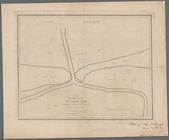
Map of the mouth of big Sandy…
abstract:
Shows proposed
pier
. Depths shown by soundings
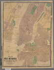
New map of the great metropol…
abstract:
…. Shows wards,
piers
New map of the great metropol…
note:
Shows wards,
piers
, and ferry lines.
m
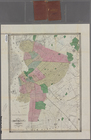
Map of Brooklyn and vicinity
abstract:
…, and
piers
. Includes
…,
Piers
[52?]-
59
), W. 14th