Click to visit the main New York Public Library Homepage
The New York Public Library
Digital Collections
About Digital Collections
Browse
Search only public domain materials
Items
Collections
Divisions
Home
Search
Browse
About
Search only public domain materials
Items
Collections
Divisions
Digital Collections
Using Images
Using Data
Search
Filtered search
Show filters
Hide filters
Show Only Public Domain
topic
Nautical charts
218
Harbors
48
Coasts
34
Navigation
28
Rivers
8
More
Less
name
Thornton, Samuel
173
United States Coast Survey
169
Bache, A. D. (Alexander Dallas), 1806-1867
147
Mathiot, G
37
Alden, James, 1810-1877
30
More
Less
collection
Maps of North America
207
Atlases, gazetteers, guidebooks and other books
174
Maps of New York City and State
12
Explanations and sailing directions to accompany the Wind and current charts,
2
Naval air pilot. West Indies including Bermuda, Bahama islands, the north coast of Colombia and Venezuela. Corrected to July 1, 1940. Notice to aviators, no. 7, 1940
2
More
Less
place
Atlantic Ocean
35
Massachusetts
25
California
24
Florida
23
Virginia
21
More
Less
genre
x
Nautical charts
Maps
397
Bathymetric maps
97
Illustrations
2
Prints
2
More
Less
publisher
U.S. Coast Survey
86
U.S. Coast Survey Office
46
United States Coast Survey
20
publisher not identified
9
Coast Survey Office
5
More
Less
division
Map Division
394
General Research Division
5
type
cartographic
399
still image
7
text
2
Date Range
to
399 results found
Filtering on:
x
Genre
: Nautical charts
Sort by:
Title
Date created
Date digitized
Sequence
m
Carte trigonométrique des côt…
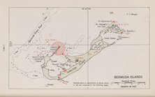
Bermuda Islands
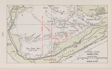
Bermuda Island. Hamilton
Key West Harbor and its appro…
Preliminary chart of Ship Isl…
Reconnaissance of Pass Fourch…
Survey of the mouth of Galien…
Survey of the mouth of Clinto…
Norfolk harbor, Virginia : fr…
State of Ohio : chart of the …
Sea Coast of Delaware, Maryla…
Preliminary chart of San Luis…
Survey of the entrance to Mil…
Reconnaissance of Semi-ah-moo…
Preliminary chart of Gray's H…
Reconnaissance of Grenville H…
Reconnaissance of Duwamish Ba…
Reconnaissance of Canal de Ha…
Chart of the Columbia River f…
Grand Island Pass, Mississipp…
Horn Island Pass, Mississippi…
Preliminary surveys of harbor…
m
Preliminary chart of Port Roy…
Map of comparison of Maffitt'…
Beaufort River, S.C. : from B…
Preliminary chart of North Ed…
Plan of the entrance into Cap…
Preliminary Chart of entrance…
Entrance to Columbia River, O…
Preliminary survey of the ent…
Reconnaissance of Port Townsh…
Reconnaissance of Olympia Har…
Rappahannock River, Virginia …
Preliminary chart of James Ri…
Preliminary sketch of Cherrys…
Chart of Green Bay
Reconnaissance of the harbors…
Preliminary survey of San Ped…
Reconnaissance of Smith's or …
Reconnaissance of Trinidad Ba…
Preliminary chart of San Pedr…
Preliminary chart of Tomales …
Preliminary chart of Drake's …
Preliminary survey of Humbold…
Reconnaissance of Catalina Ha…
Mare Island Straits, Californ…
Reconnaissance of the western…
Preliminary chart of San Pabl…
City of San Francisco and its…
San Diego Bay, California
1
2
Previous
Next
1
2
Previous
Next