Click to visit the main New York Public Library Homepage
The New York Public Library
Digital Collections
About Digital Collections
Browse
Search only public domain materials
Items
Collections
Divisions
Home
Search
Browse
About
Search only public domain materials
Items
Collections
Divisions
Digital Collections
Using Images
Using Data
Search
Filtered search
Show filters
Hide filters
Show Only Public Domain
topic
Blacks
1
Missions
1
Swedes
1
name
Bjorck, Tobias Er
1
Blome, Richard, -1705
1
Church of England
1
Covens et Mortier et Covens, junior
1
Hesselius, Andreas, 1677-1733
1
More
Less
collection
Lawrence H. Slaughter Collection of English maps, charts, globes, books and atlases
4
Maps of North America
1
place
x
Middle Atlantic States -- Maps -- Early works to 1800
Pennsylvania
5
Maryland
3
New Jersey
3
Delaware
2
More
Less
genre
Maps
5
publisher
A. Wolfgang
1
Chéz Covens et Mortier, et Covens, junior
1
Literis Wernerianis,
1
Printed by Joseph Downing
1
Printed by Joseph Downing,
1
division
Map Division
5
type
cartographic
5
Date Range
to
5 results found
Filtering on:
x
Place
: Middle Atlantic States -- Maps -- Early works to 1800
x
Place
: Pennsylvania
Sort by:
Title
Date created
Date digitized
Sequence
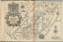
Delineatio Pennsilvaniae et C…
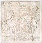
A map of the country between …
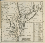
Nouvelle carte de la Pensylva…
A map of New England, New Yor…
A chorographical map of the c…