Click to visit the main New York Public Library Homepage
The New York Public Library
Digital Collections
About Digital Collections
Browse
Search only public domain materials
Items
Collections
Divisions
Home
Search
Browse
About
Search only public domain materials
Items
Collections
Divisions
Digital Collections
Using Images
Using Data
Search
Filtered search
Show filters
Hide filters
Show Only Public Domain
topic
Administrative and political divisions
9
Railroads
5
Indian reservations
2
Counties
1
Forts & fortifications
1
More
Less
name
x
Blanchard, Rufus, 1821-1904
Richards & Co
2
Thayer, H. L. (Homer Lockwood), 1837-1904
2
Colton, G. Woolworth (George Woolworth), 1827-1901
1
Davis, George (fl. ca. 1833)
1
More
Less
collection
Maps of North America
14
I. N. Phelps Stokes Collection of American Historical Prints
2
place
Chicago (Ill.)
6
Chicago
4
Illinois
4
Chicago Metropolitan Area (Ill.)
3
Colorado
2
More
Less
genre
Maps
14
Prints
2
publisher
Rufus Blanchard
7
Published by Rufus Blanchard
5
Published by Rufus Blanchard
2
Published by Richards & Co
2
Colton
1
division
Map Division
14
Wallach Division: Print Collection
2
type
cartographic
14
still image
2
Date Range
to
16 results found
Filtering on:
x
Name
: Blanchard, Rufus, 1821-1904
Sort by:
Title
Date created
Date digitized
Sequence
Map of the business and centr…
Blanchard's map of Chicago, a…
Blanchard's guide map of Chic…
Map of Chicago and its wester…
Thayer's map of Colorado
Blanchard's Guide map of Kans…
Thayer's map of Colorado
Map of Cook and DuPage Counti…
m
Blanchard's map of Cook and D…
Colton's Guide map of Michigan
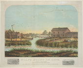
Wolf's Point in 1833.
Blanchard's map of Wisconsin …
m
G. Woolworth Colton's new gui…
m
Cabinet map of Iowa
m
Sectional, Nebraska and Kansa…
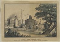
Old Fort Dearborn, erected at…
End of results
|
Top