Click to visit the main New York Public Library Homepage
The New York Public Library
Digital Collections
About Digital Collections
Browse
Search only public domain materials
Items
Collections
Divisions
Home
Search
Browse
About
Search only public domain materials
Items
Collections
Divisions
Digital Collections
Using Images
Using Data
Search
Filtered search
Show filters
Hide filters
Show Only Public Domain
topic
Administrative and political divisions
2
Antiquities & archaelogical sites
1
Farms
1
Indians of North America
1
Maps
1
name
x
Doolittle, Amos, 1754-1832
Carey, Mathew, 1760-1839
3
Shelton & Kensett
2
Sweitzer, Henry, 1771-1807
2
Thomas & Andrews
2
More
Less
collection
Maps of North America
6
Lawrence H. Slaughter Collection of English maps, charts, globes, books and atlases
2
Atlases, gazetteers, guidebooks and other books
1
place
United States
4
Vermont
2
Canada
1
Connecticut
1
Delaware
1
More
Less
genre
Maps
9
Early maps
1
Illustrations
1
publisher
Printed by H. Sweitzer, for M. Carey,
2
Shelton & Kensett
2
publisher not identified
2
M. Carey
1
Published by Thomas & Andrews,
1
More
Less
division
Map Division
9
type
x
cartographic
still image
1
Date Range
to
9 results found
Filtering on:
x
Name
: Doolittle, Amos, 1754-1832
x
Type
: cartographic
Sort by:
Title
Date created
Date digitized
Sequence
m
A correct map of the state of…
Shelton & Kensett's map of th…
A correct map of Connecticut:…
A map of the district of Main…
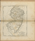
New Jersey
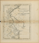
Delaware
A map of the United States an…
Map of the United States of A…
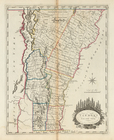
Vermont, from actual survey