Click to visit the main New York Public Library Homepage
The New York Public Library
Digital Collections
About Digital Collections
Browse
Search only public domain materials
Items
Collections
Divisions
Home
Search
Browse
About
Search only public domain materials
Items
Collections
Divisions
Digital Collections
Using Images
Using Data
Search
Filtered search
Show filters
Hide filters
Show Only Public Domain
topic
Administrative and political divisions
5
City planning
1
Early works to 1800
1
Maps
1
Nautical charts
1
name
x
Montrésor, John, 1736-1799
Andrews, Peter, active 1765-1782
4
Dury, Andrew
4
Le Rouge, Georges-Louis
3
Hayward, George, b. ca. 1800
1
More
Less
collection
x
Maps of New York City and State
place
New York (State)
5
Northeastern States
5
Manhattan (New York, N.Y.) -- Maps -- Early works to 1800
1
New York (N.Y.)
1
New York (N.Y.) -- Maps -- Early works to 1800
1
More
Less
genre
Maps
8
publisher
A. Dury ..
4
Chez Le Rouge, Ingr. Geog du Roi rue des Grands Augustins
1
Chez Le Rouge, Ingr. Geog du Roi rue des Grands Augustins,
1
Chez le Rouge, rue des Grands Augustins,
1
division
Map Division
8
type
cartographic
8
Date Range
to
8 results found
Filtering on:
x
Name
: Montrésor, John, 1736-1799
x
Collection
: Maps of New York City and State
For more collection details, visit the
Maps of New York City and State collection page
.
Sort by:
Title
Date created
Date digitized
Sequence
m
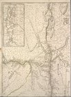
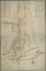
Province de New-York : en 4 f…
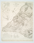
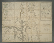
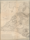
Plan de New-York et des envir…
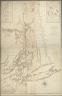
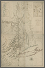
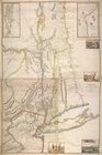
A map of the Province of New …
A map of the Province of New …
A map of the Province of New …
A map of the Province of New …
Province de New-York : en 4 f…
A Plan of the City of New-Yor…