Click to visit the main New York Public Library Homepage
The New York Public Library
Digital Collections
About Digital Collections
Browse
Search only public domain materials
Items
Collections
Divisions
Home
Search
Browse
About
Search only public domain materials
Items
Collections
Divisions
Digital Collections
Using Images
Using Data
Search
Filtered search
Show filters
Hide filters
Show Only Public Domain
topic
Nautical charts
9
Geodesy--Observations
4
Administrative and political divisions
2
Coasts
2
Navigation
2
More
Less
name
x
U.S. Coast and Geodetic Survey
Geological Survey (U.S.)
9
Gannett, Henry, 1846-1914
5
Tittmann, O. H. (Otto Hilgard), 1850-1938
5
Vermeule, C. C. (Cornelius Clarkson), 1858-1950
5
More
Less
collection
Maps of North America
31
Maps of New York City and State
5
Collection of 9 Cyanotype Prints from the Yolo Base Line Survey
4
place
Alaska
7
New Jersey
5
New York (State)
5
Yolo County (Calif.)
4
Aleutian Islands (Alaska)
3
More
Less
genre
Maps
36
Topographic maps
8
Nautical charts
7
Bathymetric maps
6
Photographs
4
More
Less
publisher
U.S. Coast and Geodetic Survey
9
U.S. Geological Survey
6
Geological Survey of New Jersey
5
United States Coast and Geodetic Survey
3
The United States Coast and Geodetic Survey
2
More
Less
division
Map Division
36
Wallach Division: Photography Collection
4
type
cartographic
36
still image
4
Date Range
to
40 results found
Filtering on:
x
Name
: U.S. Coast and Geodetic Survey
Sort by:
Title
Date created
Date digitized
Sequence
A map of New Jersey to accomp…
A map of New Jersey to accomp…
A topographical map of a part…
Alaska Peninsula and Aleutian…
Alaska Peninsula and Aleutian…
Albany and vicinity
Baltimore and its neighborhoo…
Bay and harbor of New York
Beaufort River, S.C. : from B…
Coast chart, no. 118, Napeagu…
Field comparisons of bars wit…
General chart of Alaska : com…
Hawaiian Islands
Isogonic chart of the United …
Land classification map, New …
Map of Alaska
Map of North Carolina
m
Map of Rock Creek Park, being…
Map of Teller Reindeer Statio…
Maryland - District of Columb…
Measuring across one of the D…
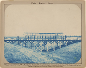
Movable tent or Yolo Buggy (5…
Patuxent River from Pt. Judit…
[Photographic copy of a print…
Preliminary chart of Calibogu…
Preliminary chart of the sea …
Reconnaissance of the western…
San Francisco Peninsula
Sketch map of Alaska
Tennessee Pikeville sheet
Tennessee Wartburg quadrangle…
m
The Dermott or tin case map o…
The gold and coal fields of A…
The State of New Jersey: from…
The State of New Jersey
Topographical map of the stat…
Washington and vicinity, Mary…
West Point, New York
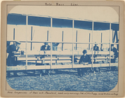
Yolo Buggy at S.E. Base at cl…
Yukon River, Alaska
End of results
|
Top