Click to visit the main New York Public Library Homepage
The New York Public Library
Digital Collections
About Digital Collections
Browse
Search only public domain materials
Items
Collections
Divisions
Home
Search
Browse
About
Search only public domain materials
Items
Collections
Divisions
Digital Collections
Using Images
Using Data
Search
Filtered search
Show filters
Hide filters
Show Only Public Domain
topic
x
Real property
Cities & towns
74
Fire insurance
74
Landowners
70
Business enterprises
67
More
Less
name
Beers, F. W. (Frederick W.)
152
Everts, Ensign & Everts
84
Sanborn Map Company
74
J.B. Beers & Co
61
F.W. Beers & Co
52
More
Less
collection
Atlases of the United States
349
Atlases of New York City
128
Maps of New York City and State
75
Maps of North America
37
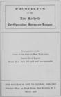
Prospectus of the New Rochelle Co-operative Business League, incorporated under laws of the State of New York, 1905
7
More
Less
place
New York (State)
509
Westchester County (N.Y.)
87
Genesee County (N.Y.)
84
Erie County
51
Erie County (N.Y.)
51
More
Less
genre
Maps
494
Atlases
346
Cadastral maps
90
Prints
61
Title pages
16
More
Less
publisher
Sanborn Map Company
74
F. W. Beers & Co
51
F. W. Beers, A. D. Ellis & others
41
Andreas, Baskin & Burr
39
Stranahan & Nichols
21
More
Less
division
Map Division
593
Schomburg Jean Blackwell Hutson Research and Reference Division
7
Manuscripts and Archives Division
1
type
cartographic
555
text
38
still image
18
Date Range
to
601 results found
Filtering on:
x
Note
: "Amer. Book Co. NY photo header 4086."--written on border.
x
Topic
: Real property
Sort by:
Title
Date created
Date digitized
Sequence
m
Map of the Cedar Knolls, at B…
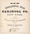
New topographical atlas of Sa…
Residence of James Carrigan, …
Hollis Terrace addition no. 1…
Property in the towns of Cast…
Map of portion of greater New…
m
Map of the southern part of W…
Map of lots to be sold at the…
m
51 lots to be sold by R.R. Mi…
m
Map of 5 valuable lots of gro…
m
Map of Rockingham Co., New Ha…
m
Map of Clinton Co., New York:…
Map of Rochester, Olmsted Co.…
Map of the Iron Cliffs Co.'s …
Map showing lands of St. Mary…
Map of a portion of the Salem…
Lots & blocks shaded red belo…
m
City of Toledo, Lucas Co., Oh…
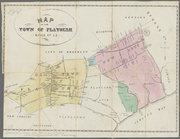
Map of the town of Flatbush, …
m
Map of Dutchess Co., New York…
m
Map of Kings and part of Quee…
Prospectus of the New Rochell…
New Rochelle Co-operative Bus…
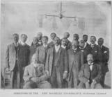
Directors of the New Rochelle…
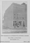
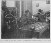
Main office of the New Rochel…
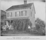
"The Douglass" ; 97 Horton Av…
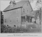
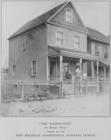
"The Washington" ; 24 Brook S…
"The Anderson" ; 21 DeWitt Pl…
Map of part of the Manor of P…
Map of the town of Eastcheste…
m
Map of Maury Co., Tennessee :…
General plan for the town of …
m
Map of Elizabeth City Co., Va…
m
Map of Clearfield Co., Pennsy…
m
Map of Cambria Co., Pennsylva…
Whitesboro, Brown Co., W.T.
m
Map of Fulton Co., Pennsylvan…
Plat of the city of Tallapoos…
Plan of the village of Lima o…
m
Map of Charlotte, Mecklenberg…
Lands of the Ogden Mining & M…
Map of West Hickory Creek, Ve…
Map of the oil region, Venang…
m
Map of Scott Co., Kentucky : …
Map of Winter Park, Orange Co…
Map of the Valley Furnace Est…
Map of property of the Bloomi…
Map of property of the Ruther…
Map of property of the Dundee…
Llewellyn Park, West Orange, …
1
2
3
Previous
Next
1
2
3
Previous
Next