Click to visit the main New York Public Library Homepage
The New York Public Library
Digital Collections
About Digital Collections
Browse
Search only public domain materials
Items
Collections
Divisions
Home
Search
Browse
About
Search only public domain materials
Items
Collections
Divisions
Digital Collections
Using Images
Using Data
Search
Filtered search
Show filters
Hide filters
Show Only Public Domain
topic
Real property
242
Fire insurance
88
Cities & towns
81
Railroads
39
History
32
More
Less
name
Sanborn Map Company
82
Rand McNally and Company
49
Everts, Ensign & Everts
43
Robinson, E. (Elisha)
34
A.H. Mueller (Publisher)
30
More
Less
collection
Atlases of the United States
195
Atlases of New York City
168
Maps of North America
102
Maps of New York City and State
51
Materīaly po istorīi russkoĭ kartografīi
7
More
Less
place
New York (State)
274
New York
63
Brooklyn (New York, N.Y.)
54
New Jersey
31
Bronx (New York, N.Y.)
29
More
Less
genre
Maps
554
Atlases
194
Prints
34
Cadastral maps
18
Illustrations
9
More
Less
publisher
Sanborn Map Company
82
A.H. Mueller
30
Topographical Bureau
25
Rand, McNally & Co
23
E. Belcher Hyde
20
More
Less
division
Map Division
520
General Research Division
22
Milstein Division
9
Rare Book Division
8
Manuscripts and Archives Division
4
More
Less
type
x
cartographic
text
17
still image
10
Date Range
to
575 results found
Filtering on:
x
Note
: [10 written pages] in wrapping leaf, with label "To S. H." Possibly by Annie Fields, but author initials not ascertained.
x
Type
: cartographic
Sort by:
Title
Date created
Date digitized
Sequence
m
Report on the work of the com…
Insvla S. Lavrentii, vulgo Ma…
Map illustrating the operatio…
m
Mercator projection exhibitin…
m
A chart of the discoveries of…
m
Map of property belonging to …
Rand, McNally & Co.'s new aut…
m
Rand, McNally & Co.'s complet…
Wall St. New York City, U.S.A…
Rand, McNally & Co.'s new han…
Rand McNally & Co.'s new hand…
m
Rand McNally & Co.'s road map…
Map of portion of greater New…
m
Osnovnyi︠a︡ soobrazhenīi︠a︡ k…
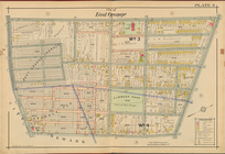
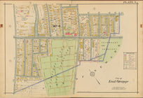
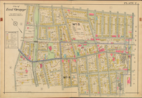
City of East Orange, Double P…
City of East Orange, Double P…
City of East Orange, Double P…
City of East Orange, Double P…
City of East Orange, Double P…
Atlas of the Oranges embracin…
m
N.Y.C. & H.R.R.R. Electric Zo…
m
H.M.S. Aeolus and H.M.S. Norw…
H4. Map (Scheme B) illustrati…
Insvla S. Lavrentii, vulgo Ma…
H Diagram of the state of Mis…
m
Rand, McNally & Co.'s Minneso…
Rand, McNally & Co.'s Illinoi…
Rand, McNally & Co.'s New Jer…
Map--S'emka Bolgarii mezhdu R…
S'emka Bolgarii mezhdu R. R. …
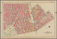
Bounded by 58th Street, West …
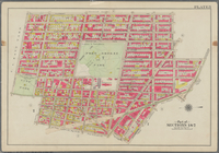
Bounded by Metropolitan Ave.,…
Bounded by S. 11th Street, Be…
Bounded by Fifth Avenue, Atla…
Bounded by Clermont Avenue, G…
m
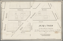
Map of lots to be sold at auc…
Map of lots to be sold at auc…
Rand McNally & Co.'s North Da…
Rand McNally & Co.'s new sect…
m
The World's Industrial and Co…
H. Diagram of the State of Mi…
Map of a portion of Point Ke…
Rand, McNally & Co.'s Minneso…
m
Nelson, R.H
Map of the Iron Cliffs Co.'s …
Map of a portion of the Salem…
J.L. Hill Printing Co.'s map …
Rand, McNally & Co.'s Missouri
m
Rand, McNally & Co.'s map sho…
m
Map of the vicinity of Philad…
1
2
3
Previous
Next
1
2
3
Previous
Next