Click to visit the main New York Public Library Homepage
The New York Public Library
Digital Collections
About Digital Collections
Browse
Search only public domain materials
Items
Collections
Divisions
Home
Search
Browse
About
Search only public domain materials
Items
Collections
Divisions
Digital Collections
Using Images
Using Data
Search
Filtered search
Show filters
Hide filters
Show Only Public Domain
topic
Real property
1257
Fire insurance
750
Cities & towns
731
Railroads
41
History
37
More
Less
name
Sanborn Map Company
734
G.W. Bromley & Co
245
Ullitz, Hugo
146
E.B. Hyde & Co
145
Bromley, George Washington
130
More
Less
collection
Atlases of New York City
1320
Atlases of the United States
336
Maps of North America
106
Maps of New York City and State
81
Bancker plans
35
More
Less
place
New York (State)
1335
New York
405
Manhattan (New York, N.Y.)
215
Brooklyn (New York, N.Y.)
203
New York (N.Y.)
160
More
Less
genre
Maps
1964
Atlases
335
Prints
38
Surveys
37
Cadastral maps
33
More
Less
publisher
Sanborn Map Company
735
G.W. Bromley & Co
207
E. Belcher Hyde
158
A.H. Mueller
65
E. Robinson Co
50
More
Less
division
Map Division
1858
Manuscripts and Archives Division
42
General Research Division
25
Rare Book Division
15
Milstein Division
12
More
Less
type
x
cartographic
still image
30
text
29
Date Range
to
1,984 results found
Filtering on:
x
Note
: Manuscript notation "U.S. Light House Rept. 1898" in lead and printed numeral "3" in red ink on verso.
x
Type
: cartographic
Sort by:
Title
Date created
Date digitized
Sequence
Insvla S. Lavrentii, vulgo Ma…
Map illustrating the operatio…
World on gnomonic projection …
m
Mercator projection exhibitin…
m
A chart of the discoveries of…
m
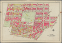
Map of property belonging to …
Rand, McNally & Co.'s new aut…
m
Rand, McNally & Co.'s complet…
Wall St. New York City, U.S.A…
Rand, McNally & Co.'s new han…
Rand McNally & Co.'s new hand…
m
Hagstrom's map of upper New Y…
m
Rand McNally & Co.'s road map…
Hagstrom's New York house-num…
Map of portion of greater New…
Hagstrom's map of ... New Yor…
m
Map 3 - Manhattan and Bronx
m
Osnovnyi︠a︡ soobrazhenīi︠a︡ k…
Village of South Orange, Doub…
Village of South Orange, Doub…
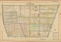
City of East Orange, Double P…
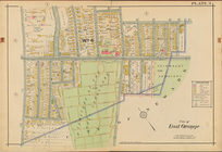
City of East Orange, Double P…
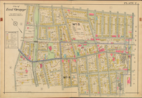
City of East Orange, Double P…
City of East Orange, Double P…
City of East Orange, Double P…
m
H.M.S. Aeolus and H.M.S. Norw…
Plan for preservation of Audu…
Insvla S. Lavrentii, vulgo Ma…
m
Rand, McNally & Co.'s Minneso…
Rand, McNally & Co.'s Illinoi…
Rand, McNally & Co.'s New Jer…
Map showing condition and pro…
Map--S'emka Bolgarii mezhdu R…
S'emka Bolgarii mezhdu R. R. …
Bounded by Avenue K., Ralph A…
Bounded by Avenue P., E. 31st…
Coney Island. Bounded by Cana…
Bounded by Ocean Avenue, Emmo…
Bounded by Ocean Parkway, Ave…
Bounded by Avenue Q., Ocean A…
Bounded by 72nd Street, 22nd …
Bounded by 58th Street, West …
Bounded by 85th Street, 1st A…
Bounded by Mackay Pl., 1st Av…
Bounded by Metropolitan Ave.,…
Bounded by S. 11th Street, Be…
Bounded by Fifth Avenue, Atla…
Bounded by Clermont Avenue, G…
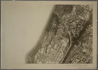
3A - N.Y. City (Aerial Set).
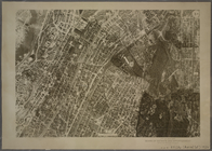
3B - N.Y. City (Aerial Set).
1
2
3
4
5
6
7
8
Previous
Next
1
2
3
4
5
6
7
8
Previous
Next