Click to visit the main New York Public Library Homepage
The New York Public Library
Digital Collections
About Digital Collections
Browse
Search only public domain materials
Items
Collections
Divisions
Home
Search
Browse
About
Search only public domain materials
Items
Collections
Divisions
Digital Collections
Using Images
Using Data
Search
Filtered search
Show filters
Hide filters
Show Only Public Domain
topic
Real property
818
Fire insurance
528
Cities & towns
519
Maps
10
City planning
6
More
Less
name
Sanborn Map Company
520
Ullitz, Hugo
210
E.B. Hyde & Co
150
E. Belcher Hyde Map Company
148
G.W. Bromley & Co
134
More
Less
collection
x
Atlases of New York City
place
New York (State)
899
New York
339
Brooklyn (New York, N.Y.)
178
Manhattan (New York, N.Y.)
103
Queens (New York, N.Y.)
99
More
Less
genre
Maps
1064
Indexes
4
Title pages
3
Topographic maps
2
Cadastral maps
1
More
Less
publisher
Sanborn Map Company
521
E. Belcher Hyde
303
G.W. Bromley & Co
126
E. Robinson Co
32
E. Belcher Hyde
17
More
Less
division
Map Division
1069
type
cartographic
1059
text
8
still image
6
Date Range
to
1,071 results found
Filtering on:
x
Note
: Written on mount: "June 2, 1866"
x
Collection
: Atlases of New York City
For more collection details, visit the
Atlases of New York City collection page
.
Sort by:
Title
Date created
Date digitized
Sequence
m
Map 2 - Bronx
Bounded by 85th Street, 1st A…
Bounded by Mackay Pl., 1st Av…
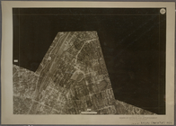
2A - N.Y. City (Aerial Set).
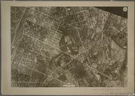
2C - N.Y. City (Aerial Set).
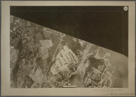
2D - N.Y. City (Aerial Set).
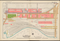
Double Page Plate No. 2, Part…
Double Page Plate No. 2, Part…
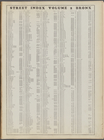
Street Index, Volume 2, Bronx…
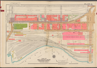
Double Page Plate No. 2, Part…
Bounded by W. 12th St., Avenu…
Map bounded by Houston Street…
Map bounded by 6th Street, Av…
Plate 2: Map bounded by South…
m
Plate 2: [Bounded by Carlisle…
Plate 1: Bounded by Liberty S…
Plate 2: Bounded by Jay Stree…
Plate 2: Bounded by West Stre…
Street Index [2], [Hudson Str…
Plate 2: Bounded by Adams Str…
Plate 14: Bounded by Third Av…
Plate 21: Bounded by Grand St…
Plate 22: Bounded by N. 14th …
Plate 25: Bounded by 2nd Stre…
Plate 2: [Bounded by Clark St…
m
Plate 2: Bounded by (East Riv…
Bounded by Seventeenth Avenue…
Bounded by (U.S. Government R…
Plate 2: [Bounded by Fenimore…
Plate 9: [Bounded by 85th Str…
Sheet 2: Map encompassing Pro…
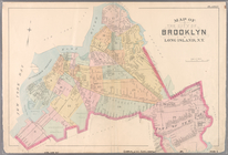
Plate 2: Map of the City of B…
Plate 2: Map No. 419 [Bounded…
Plate 14: Vol. 3 of Maps, Pag…
Plate 35: Map No. 45 [Bounded…
Plate 38: Vol. 3 of Maps, Pag…
Plate 2: [Bounded by E. 144th…
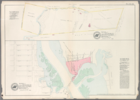
Plate 2, Part of Section 3: […
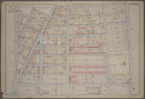
Plate 2, Part of Section 4: […
Double Page Plate No. 2, Part…
Elton Avenue - Yonkers Avenue…
Plate 2, Part of Sections 9&1…
Plate 2: Part of Section 9, B…
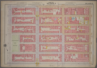
Plate 2, Part of Section 3: […
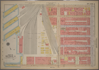
Plate 2, Part of Section 4: […
m
Plate 2, Part of Section 3: […
Sheet 2: Grid #8000E - 12000E…
Section 1: Map or Plan of Sec…
Sheet No. 2. [Includes Richmo…
Detailed Estate and Old Farm …
1
2
3
4
5
Previous
Next
1
2
3
4
5
Previous
Next