Click to visit the main New York Public Library Homepage
The New York Public Library
Digital Collections
About Digital Collections
Browse
Search only public domain materials
Items
Collections
Divisions
Home
Search
Browse
About
Search only public domain materials
Items
Collections
Divisions
Digital Collections
Using Images
Using Data
Search
Filtered search
Show filters
Hide filters
Show Only Public Domain
topic
x
Real property
Landowners
160
Administrative and political divisions
50
Railroads
22
Estate
16
More
Less
name
Dripps, M. (Matthew)
20
Miller & Co
16
Smith, Robert Pearsall, 1827-1898
16
Welcke, Robert A
11
J.B. Beers & Co
7
More
Less
collection
x
Maps of New York City and State
place
x
New York (State)
New York
116
New York (N.Y.)
55
Brooklyn (New York, N.Y.)
46
Manhattan (New York, N.Y.)
25
More
Less
genre
Maps
296
Cadastral maps
159
Manuscript maps
23
Aerial views
3
Facsimiles
3
More
Less
publisher
publisher not identified
36
M. Dripps
15
s.n
11
publisher unknown
8
J.B. Beers & Co
7
More
Less
division
Map Division
296
type
cartographic
293
still image
7
text
2
Date Range
to
296 results found
Filtering on:
x
Location
: Map Division
x
Place
: New York (State)
x
Rights
: Public Domain
x
Collection
: Maps of New York City and State
x
Topic
: Real property
For more division details, visit the
Lionel Pincus and Princess Firyal Map Division division page
.
Sort by:
Title
Date created
Date digitized
Sequence
m
Map of property belonging to …
Map of lots belonging to the …
Map of Brooklyn Manor
Map of Flatbush Meadows : sit…
Tracts and farms with street …
Rosedale Square, Rosedale : 4…
Map of Jamaica in the 4th war…
Map of property New York Dock…
Map of Kissena Park, third wa…
Block sketch 1679, New York C…
East River Heights, first war…
Map of Bellaire Estates : own…
Hollis Terrace addition no. 1…
Map of 272 lots in the 30th w…
Map of Jamaica Fells : fourth…
m
Map of the borough of Queens,…
Borough Park Company
m
Sea Gate, New York Harbor
Map of Elmhurst Square : situ…
Plan of the great meadows of …
Property in the towns of Cast…
Map of property in the 19th w…
m
Topographical map of New York…
m
Map of the City of Brooklyn a…
m
Peremptory sale of a suburban…
Flushing
Block no. 86 : confidential r…
Livingston Heights : Livingto…
Map of portion of greater New…
m
Lands of the Harlaem Canal Co…
m
Map of the southern part of W…
m
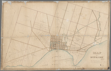
Map of Ulster County, New York
m
Map of Washington County, New…
Map of the port & vicinity of…
m
Map of Clinton Co., New York:…
Map of the town of Flatbush, …
m
Map of Dutchess Co., New York…
m
Map of Kings and part of Quee…
m
Map of Long Island: based upo…
m
Map of Albany County, New Yor…
m
Map of Long Island: based upo…
Map of part of the Manor of P…
Map of the town of Eastcheste…
Map of Great Barn Island, New…
Map of the "Hunter Fly Farm" …
A map of part of the land in …
Map of Long Island: showing t…
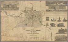
Map of the village of Auburn
m
Map of Dunkirk
Map of the head waters of the…
1
2
Previous
Next
1
2
Previous
Next