Click to visit the main New York Public Library Homepage
The New York Public Library
Digital Collections
About Digital Collections
Browse
Search only public domain materials
Items
Collections
Divisions
Home
Search
Browse
About
Search only public domain materials
Items
Collections
Divisions
Digital Collections
Using Images
Using Data
Search
Filtered search
Show filters
Hide filters
Show Only Public Domain
topic
Administrative and political divisions
1
Canals
1
Geology
1
name
Balch, Rawdon & Co
2
Vance, David H
2
Balch, Vistus, 1799-1884
1
Dey, John Ogden
1
S. Stiles & Co
1
More
Less
collection
Maps of New York City and State
4
place
x
Erie Canal (N.Y.) -- Altitudes -- Charts, diagrams, etc
New York (State)
3
New York (State) -- Maps
3
New York (State) -- Administrative and political divisions -- Maps
2
Erie Canal (N.Y.) -- Maps
1
More
Less
genre
Maps
4
publisher
D. H. Vance,
1
D. Steele
1
John Ogden Dey,
1
William Williams,
1
division
Map Division
4
type
x
cartographic
Date Range
to
4 results found
Filtering on:
x
Place
: Erie Canal (N.Y.) -- Altitudes -- Charts, diagrams, etc.
x
Type
: cartographic
Sort by:
Title
Date created
Date digitized
Sequence
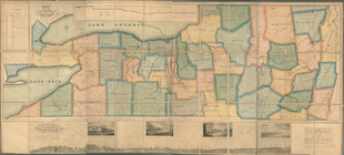
Map of the western part of th…
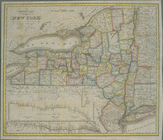
The tourist's map of the stat…
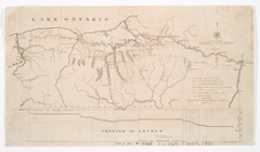
Map of part of New York State…
m
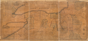
Map of the western part of th…