Click to visit the main New York Public Library Homepage
The New York Public Library
Digital Collections
About Digital Collections
Browse
Search only public domain materials
Items
Collections
Divisions
Home
Search
Browse
About
Search only public domain materials
Items
Collections
Divisions
Digital Collections
Using Images
Using Data
Search
Filtered search
Show filters
Hide filters
Show Only Public Domain
topic
x
Nautical charts
name
Cornel, Antonio
1
Cruchley, G. F
1
E. & G.W. Blunt (Firm)
1
Hooker, William, 1782-1856
1
J. & C. Walker
1
More
Less
collection
x
Maps of the Oceans
place
x
Atlantic Ocean
Maps
4
North Atlantic Ocean
3
Early works to 1800
2
Hurricane, 1830 Oct. 1
1
More
Less
genre
Maps
5
publisher
Anthony Iacobsz op t'Water inde Lootsman,
1
Deposito Hidrografico
1
G.F. Cruchley, map seller and publisher
1
Published ... by J. & A. Walker ...,
1
Published by E. & G.W. Blunt
1
division
Map Division
5
type
cartographic
5
Date Range
to
5 results found
Filtering on:
x
Place
: Atlantic Ocean
x
Collection
: 5fe47390-c6bf-012f-c9cf-58d385a7bc34
x
Topic
: Nautical charts
Sort by:
Title
Date created
Date digitized
Sequence
Carta general del Oceano Atla…
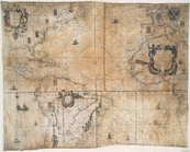
West-Indische paskaert: waer …
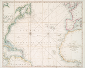
A chart of the Atlantic or We…
m
A chart of the Atlantic or We…
Chart of the Atlantic Ocean :…