Click to visit the main New York Public Library Homepage
The New York Public Library
Digital Collections
About Digital Collections
Browse
Search only public domain materials
Items
Collections
Divisions
Home
Search
Browse
About
Search only public domain materials
Items
Collections
Divisions
Digital Collections
Using Images
Using Data
Search
Filtered keyword search
Show filters
Hide filters
Show Only Public Domain
topic
Nautical charts
2
Discoveries in geography
1
Magnetic declination
1
name
Bew, John, d. 1793
1
Halley, Edmond, 1656-1742
1
Harris, I
1
Jefferys, Thomas, d. 1771
1
Keulen, Gerard van
1
More
Less
collection
Lawrence H. Slaughter Collection of English maps, charts, globes, books and atlases
2
Maps of the Oceans
2
I. N. Phelps Stokes Collection of American Historical Prints
1
Maps of North and South America
1
place
x
Atlantic Ocean
North America
2
North Atlantic Ocean
2
Africa, North
1
America
1
More
Less
genre
Maps
6
Prints
1
publisher
Donnè au public, par And. & Henry de Leth ... sur le Pont de la Bourse au Pescheur
1
J. Bew
1
Joannes van Keulen boeckverkooper en graed-boogh maecker aende nieuwe brug in de gekroonde Lootsman
1
Publish[e]d according to Act of Parliament by T. Jefferys, the corner of St. Martins Lane, Charing Cross,
1
This chart is to be sold by Rich. Mount and Tho. Page at the Postern on Tower-Hill,
1
division
Map Division
5
Wallach Division: Print Collection
1
type
cartographic
6
still image
1
Date Range
to
6 results found for:
x
North Africa Maps
Filtering on:
x
Place
: Atlantic Ocean
Sort by:
Relevance
Title
Date created
Date digitized
Sequence
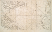
Nieuwe wassende Graade Zee ka…
note:
Stokes Addenda,
Maps
, C.1690-
Maps
-8
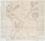
A new and correct chart shewi…
note:
Shows
North
… : with part of Europe,
Africa
note:
Jolly, D.C.
Maps
of America in periodicals
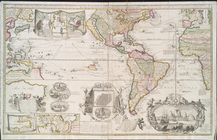
… settlements in
North
America
note:
… topography of
North
America
… de custen van
Africa
note:
Oriented with
north
to the right.
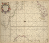
Carte nouvelle de la mer du S…
note:
…, and
Africa
.