Click to visit the main New York Public Library Homepage
The New York Public Library
Digital Collections
About Digital Collections
Browse
Search only public domain materials
Items
Collections
Divisions
Home
Search
Browse
About
Search only public domain materials
Items
Collections
Divisions
Digital Collections
Using Images
Using Data
Search
Filtered keyword search
Show filters
Hide filters
Show Only Public Domain
topic
Streets
5
Railroads
4
Real property
4
Geology
3
Historical geography
3
More
Less
name
Bien, Julius, 1826-1909
16
Julius Bien & Co
16
New York (N.Y.). Department of Parks. Topographical Division
16
Vermeule, C. C. (Cornelius Clarkson), 1858-1950
16
Viele, Egbert L. (Egbert Ludovicus), 1825-1902
5
More
Less
collection
Atlases of New York City
20
Maps of New York City and State
20
Atlases of the United States
15
I. N. Phelps Stokes Collection of American Historical Prints
4
Maps of North America
2
More
Less
place
x
New York (N.Y.)
New York (State)
22
New York Metropolitan Area
18
Westchester County (N.Y.)
17
New York
12
More
Less
genre
Maps
58
Topographic maps
22
Atlases
15
Prints
3
Cadastral maps
2
More
Less
publisher
Department of Public Parks?
16
Julius Bien & Co
15
E.L. Viele
3
Board of Public Improvements, Topographical Bureau
2
Department of Public Parks
2
More
Less
division
Map Division
57
Wallach Division: Print Collection
4
Wallach Division: Picture Collection
1
type
cartographic
58
text
3
still image
1
Date Range
to
62 results found for:
x
Topographic maps
Filtering on:
x
Place
: New York (N.Y.)
Sort by:
Relevance
Title
Date created
Date digitized
Sequence
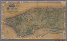
Map
accompanying
m
Topographical
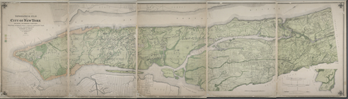
atlas of the city of New York
note:
One
map
in 5 sheets.
New York City and environs : …
collection:
Maps
of New York City and State
m
Asher & Adams' new
topographical
map
of the state
note:
Mapping
the Nation (NEH grant, 2015-2018)…
List of Plates and References
collection:
… in a series of
maps
m
Double Page Plate No. 12: Wes…
collection:
… in a series of
maps
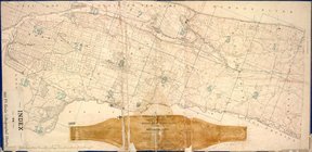
Plate No. 1: Index Map
collection:
… in a series of
maps
m
Double Page Plate No. 5: Rich…
collection:
… in a series of
maps
m
Double Page Plate No. 13: Wes…
collection:
… in a series of
maps
m
Double Page Plate No. 6: Newa…
collection:
… in a series of
maps
m
Double Page Plate No. 2: City…
collection:
… in a series of
maps
m
Double Page Plate No. 11: Wes…
collection:
… in a series of
maps
m
Double Page Plate No. 7: Newa…
collection:
… in a series of
maps
m
Double Page Plate No. 8: Long…
collection:
… in a series of
maps
m
Double Page Plate No. 3: Broo…
collection:
… in a series of
maps
m
Double Page Plate No. 10: Wes…
collection:
… in a series of
maps
m
Double Page Plate No. 9: West…
collection:
… in a series of
maps
m
Double Page Plate No. 4: The …
collection:
… in a series of
maps
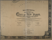
Map
or plan showing the street system in the 12th
note:
…
Topographical
Engineer
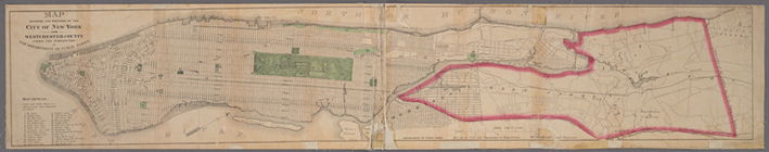
Atlas of the Metropolitan Dis…
collection:
… in a series of
maps
A
topographical
map
of a part of northern New
note:
Mapping
the Nation (NEH grant, 2015-2018)…
m
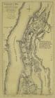
General
map
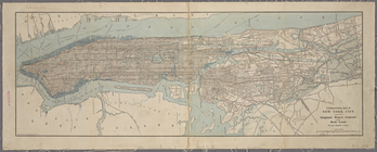
of the city of New York
note:
Note mounted on
map
: The original of this
map
Map
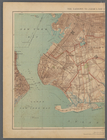
of the Marine Hospital ground, Staten
note:
… to Early
Maps
of the Middle
m
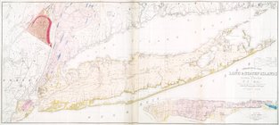
Geological
map
of Long & Staten islands
note:
Includes inset "
Map
of New-York Island."…
m
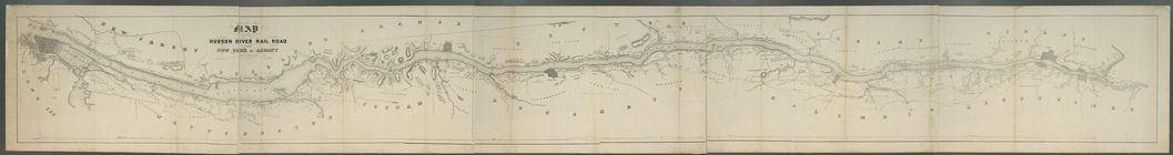
Map
of the Hudson River Rail Road from New
note:
… to Early
Maps
of the Middle
m
Map
of New York exhibiting the post offices
note:
LC Railroad
maps
, 259
m
Property identification
map
of Inwood Hill
note:
Blueprint of
map
, indicating property owners
A
map
of the provinces of New-York
note:
LC
Maps
of North America, 1750-1789, 1048
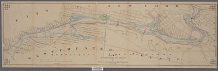
Plan of High Bridge Park : pr…
collection:
Maps
of New York City and State
Plan of the city of New York …
note:
… to buildings and
topographical
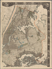
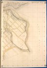
Topographical
map
of the city and county of New
collection:
Topographical
map
of the city and county
A
topographical
map
of the northn. part of New York
Index to 300 ft. scale lithog…
collection:
Topographical
map
made from surveys
Map
showing
Topographical
map
of New York City
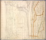
m
Topographical
map
of New York City, county
note:
Cadastral
map
covering area south of 155
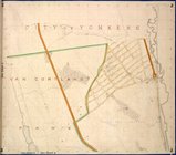
Map
of the City of New York and vicinity
note:
…"New York, December 1892
Topographical
m
Sanitary &
topographical
map
of the city
note:
Street
map
overlaid on
topographical
map
.
m
Sanitary &
topographical
map
of the city
note:
Street
map
overlaid on
topographical
map
.
Afbeeldinge van de Stadt Amst…
note:
… and the Manatus
map
of the island
Topographical
map
of New York City, County
note:
Mapping
the Nation (NEH grant, 2015-2018)…
Copy of
map
or survey showing streets
note:
Includes text certifying this
map
m
General
map
of the city of New York
note:
Note mounted on
map
: The original of this
map
Topographical
map
of the northern part of New York
Bronx,
Topographical
Map
Sheet 13; [
Map
Bronx,
Topographical
Map
Sheet 2; [
Map
Bronx,
Topographical
Map
Sheet 7; [
Map
Bronx,
Topographical
Map
Sheet 10; [
Map
Bronx,
Topographical
Map
Sheet 14; [
Map
Bronx,
Topographical
Map
Sheet 9; [
Map