Click to visit the main New York Public Library Homepage
The New York Public Library
Digital Collections
About Digital Collections
Browse
Search only public domain materials
Items
Collections
Divisions
Home
Search
Browse
About
Search only public domain materials
Items
Collections
Divisions
Digital Collections
Using Images
Using Data
Search
Filtered search
Show filters
Hide filters
Show Only Public Domain
topic
x
Nautical charts
Trade routes
2
Trade winds
2
name
Bellin, Jacques Nicolas, 1703-1772
2
Bowen, Emanuel, d. 1767
2
Choiseul, Etienne-François, duc de, 1719-1785
2
Cooper, Thomas, d. 1743
2
Cornel, Antonio
1
More
Less
collection
x
Maps of the Oceans
place
x
North Atlantic Ocean
Maps
6
Early works to 1800
5
Atlantic Ocean
3
Hurricane, 1830 Oct. 1
1
More
Less
genre
Maps
9
publisher
Depost des cartes, plans et journaux de la marine
2
Deposito Hidrografico
1
Dépôt-général de la marine
1
J. Jansson
1
Publish'd ... & sold by T. Cooper at the Globe in Pater noster Row,
1
More
Less
division
Map Division
9
type
cartographic
9
Date Range
to
9 results found
Filtering on:
x
Place
: North Atlantic Ocean
x
Collection
: 5fe47390-c6bf-012f-c9cf-58d385a7bc34
x
Topic
: Nautical charts
Sort by:
Title
Date created
Date digitized
Sequence
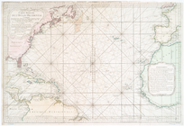
Carta general del Oceano Atla…
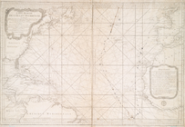
Carte réduite de l'Ocean occi…
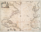
Mar del nort
A new chart of the vast Atlan…
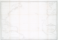
Tableau des courants observés…
m
A chart of the Atlantic or We…
Chart of the Atlantic Ocean :…
A new chart of the vast Atlan…
Carte réduite de l'Ocean occi…