Click to visit the main New York Public Library Homepage
The New York Public Library
Digital Collections
About Digital Collections
Browse
Search only public domain materials
Items
Collections
Divisions
Home
Search
Browse
About
Search only public domain materials
Items
Collections
Divisions
Digital Collections
Using Images
Using Data
Search
Filtered keyword search
Show filters
Hide filters
Show Only Public Domain
topic
History
7
Railroads
3
Canals
2
Indians of North America
2
Roads
2
More
Less
name
American Civil War (1861-1865)
2
Baltimore and Ohio Railroad Company
2
Breese, Samuel, 1802-1873
2
Morse, Sidney E. (Sidney Edwards), 1794-1871
2
Robert de Vaugondy, Gilles, 1688-1766
2
More
Less
collection
Maps of North America
17
Atlases of the United States
2
Lawrence H. Slaughter Collection of English maps, charts, globes, books and atlases
2
I. N. Phelps Stokes Collection of American Historical Prints
1
United States Sanitary Commission records. Condensed historical matter
1
place
x
United States
Ohio
11
Illinois
4
Indiana
4
Michigan
4
More
Less
genre
Maps
22
Cadastral maps
1
Early maps
1
Early works to 1800
1
Facsimiles
1
More
Less
publisher
S. E. Morse & co.,
2
s.n.,
2
Academia Regia Scientiarum et Elegantium Litterarum
1
Asher & Adams
1
Ezra Strong
1
More
Less
division
Map Division
21
Manuscripts and Archives Division
1
Wallach Division: Print Collection
1
type
cartographic
22
notated music
1
still image
1
text
1
Date Range
to
23 results found for:
x
ohio map
Filtering on:
x
Place
: United States
Sort by:
Relevance
Title
Date created
Date digitized
Sequence
Map
of Port-Lawrence & Vistula, which
note:
… catalog of the
Map
Map
of the states of Indiana and
Ohio
…
note:
NYPL
Map
Div. copy has accession no
The states of
Ohio
, Indiana & Illinois
note:
NYPL
Map
Div. copy lacks covers; filed flat.
A
map
of part of the N. W. Territory
note:
…
Ohio
.
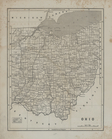
Ohio
.
note:
Issued in parts;
maps
dated 1841-1845.
Map
of the frontiers of the northern
note:
…, Virginia, and
Ohio
.
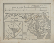
Maryland and Delaware.
note:
Issued in parts;
maps
dated 1841-1845.
Map
of the western states to illustrate
note:
…, Illinois, Indiana,
Ohio
Map
of the American colonies and adjacent
note:
… by the Baltimore and
Ohio
Railroad
Map
of the states of
Ohio
Indiana & Illinois
note:
NYPL
Map
Div. copy originally folded to 15 x 8
Map
of Camp Chase
Plan of the western seat of w…
note:
General
map
m
Map
of the United States : exhibiting
note:
… to Early
Maps
of the Middle
… comprend le cours de l'
Ohio
note:
… to Early
Maps
of the Middle
A
map
of the United States and British
note:
… States, this
map
Theatrum belli in America Sep…
note:
Brown, L. Early
maps
of the
Ohio
Valley
Map
of the country embracing the several routes
note:
NYPL
Map
Div. copy has accession no
G. Woolworth Colton's
map
of the country 500
note:
Circular
map
centered on Cairo, Ill
Map
of the boundary line between the states
note:
Mapping
the Nation (NEH grant, 2015-2018)…
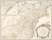
North America from the French…
note:
Copy in
Map
Div. 97-6220: Lawrence H
m
A
map
of Cabotia
note:
Map
borders Include "longitude west of Greenwich."…
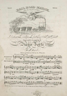
Rail road march. For the Fou…
note:
… of the Baltimore &
Ohio
Railroad.
… de l'
Ohio
, la Nlle
note:
NYPL copy in
Map
Div. 97-6097 &
Map
Div
End of results
|
Top