Click to visit the main New York Public Library Homepage
The New York Public Library
Digital Collections
About Digital Collections
Browse
Search only public domain materials
Items
Collections
Divisions
Home
Search
Browse
About
Search only public domain materials
Items
Collections
Divisions
Digital Collections
Using Images
Using Data
Search
Filtered keyword search
Show filters
Hide filters
Show Only Public Domain
topic
Real property
7
Geology
5
Railroads
5
Copper mines and mining
4
Indians of North America
4
More
Less
name
Ackerman Lithr
4
Foster, J. W. (John Wells), 1815-1873
4
Whitney, J. D. (Josiah Dwight), 1819-1896
4
Abert, John James, 1788-1863
3
Hill, S. W. (Samuel Worth), 1815-1889
3
More
Less
collection
Maps of North America
38
Maps of New York City and State
4
Maps of North and South America
1
place
Michigan
10
Massachusetts
5
United States
5
West (U.S.)
4
East (U.S.)
3
More
Less
genre
Maps
43
Cadastral maps
5
Geological maps
4
Nautical charts
4
Bathymetric maps
2
More
Less
publisher
x
publisher not identified
division
Map Division
43
type
x
cartographic
Date Range
to
43 results found for:
x
S. W
Filtering on:
x
Publisher
: publisher not identified
x
Type
: cartographic
Sort by:
Relevance
Title
Date created
Date digitized
Sequence
Plan of the New Haven City bu…
note:
Surveyed Sep. 3d, 1862 by
S.W
. Searl
Geological map of Keweenaw Po…
note:
…. geologists ;
S.W
. Hill and
W
Geological map of Isle Royale…
note:
… ; assisted by
S.W
. Hill &
W.S
Geological map of the distric…
note:
… ;
S.W
. Hill &
W
Vernon Co., Mo. : plat of tow…
note:
…"
W
.
S
. Pope, execr.; 3380 acres."…
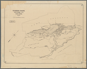
Tuxedo Park, Orange Co., New …
note:
… by Ernest
W
. Bowditch
Map of Port-Lawrence & Vistul…
note:
… feet to the inch (
W
83°32ʹ42ʺ--
W
83°31ʹ09ʺ/N
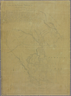
Map of Indian Territory
note:
Scale approximately 1:1,500,000 (
W
100°02ʹ--
W
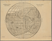
Universale della parte del mo…
note:
Scale not given (
W
157°31ʹ00ʺ--
W
6°46ʹ00ʺ/N
Plan of the entrance into Cap…
abstract:
… &
W
Map of the rail roads of the …
note:
Scale approximately 1:1,000,000 (
W
80°20ʹ--
W
71°20
Sketch of the claims to land …
note:
Scale approximately 1:3,000 (
W
84°22ʹ37ʺ--
W
Map of the city of Concord, N…
note:
…
W
. Sanborn, 1856.
Map illustrating the plan of …
note:
…, U.
S
.T.E., by
W
. Hood.
Plat of a survey of land "for…
note:
Scale approximately 1:2,500 (
W
84°21ʹ/N 46°30ʹ).
Map of the territory of Flori…
note:
… by
W
.H. Swift Lt. Artillery. ;
W
.I. Stone sc.
m
Map showing Indian reservatio…
note:
Scale approximately 1:7,500,000 (
W
126°--
W
86°/N
Geological map of the distric…
note:
J.
W
. Foster & J.D. Whitney, U.
S
. geologists.
Chart of Narraganset Bay : su…
note:
…, Secretary of the Navy ;
W
Diagram of the state of Misso…
note:
Scale not given (
W
95°46ʹ--
W
89°05ʹ/N 40°36
m
Outline map showing a new rou…
note:
… of Engineers, U.
S
.A. ; compiled & drawn by Chas.
W
Plan of the siege of Charlest…
note:
Scale approximately 1:40,000 (
W
80°08ʹ37ʺ--
W
Ohio boundary, no. 111, south…
note:
… by Lieut
W
. Hood, 1835.
A map of part of Alabama & Fl…
note:
…, U.
S
. Asst. Civil Engr.
Map of a portion of Point Keweenaw, L.
S
. …
note:
… mile to an inch (
W
88°11ʹ--
W
87°40ʹ/N 47°30
Survey of the mouth of Clinto…
note:
… feet to one inch (
W
82°56ʹ--
W
82°44ʹ/N 42°40
Aboriginal America east of th…
note:
Scale [ca. 1:17,500,000] (
W
92°--
W
68°/N
Geological map of Isle Royale…
note:
Scale approximately 1:142,000 (
W
89°17ʹ--
W
88°23
m
Charleston Harbour and the ad…
note:
…. Eakin,
W
.M. Boyce,
S
Plan of lots on Bunker Hill
note:
by
S
.M. Felton, surveyed and drawn, May
Plan of Lovejoy's narrows fro…
note:
… ; engraved by B. Chambers,
W
… Coke & Iron Co.'
s
lands
note:
… by J.
W
. Harden.
A map of part of Alabama & Fl…
note:
…, U.
S
. Asst. Civil Engr.
Map of a reconnoissance betwe…
note:
…. J.
W
. Gunnison, Corps
Survey for a ship canal aroun…
note:
… the direction of
W
.G. Williams, Capt. U.
S
.T.E. assisted
Map of the canals and rail ro…
note:
…,
S.W
. cor. 2d & Dock
Plan of the village of Marque…
abstract:
….47-48 N, R. 24-28
W
Plan of the former township o…
note:
By
S
.H. Stebbins
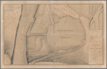
Map of the city of Boston and…
note:
Drawn by G.
W
. &
W.S
. Bromley, Phila
Plan of the cemetery of Mount…
m
Military map of Nebraska and …
note:
….
W.S
. Harney, commg
Plan of Groton Cemetery
Map of the United States and …
note:
… the order of
W
.H. Emory
End of results
|
Top