Click to visit the main New York Public Library Homepage
The New York Public Library
Digital Collections
About Digital Collections
Browse
Search only public domain materials
Items
Collections
Divisions
Home
Search
Browse
About
Search only public domain materials
Items
Collections
Divisions
Digital Collections
Using Images
Using Data
Search
Filtered keyword search
Show filters
Hide filters
Show Only Public Domain
topic
Administrative and political divisions
1
Altitudes
1
Banana trade
1
Blacks
1
Boats
1
More
Less
name
Balch, Vistus, 1799-1884
1
Fitch, John, 1743-1798
1
Hutchings, John, cooper
1
Michelin, Francis, 1809 or 1810-1878
1
Penniman, John, approximately 1817-1850
1
More
Less
collection
Maps of New York City and State
2
Lands of the Caribbean: the Canal Zone, Panama, Costa Rica, Nicaragua, Salvador, Honduras, Guatemala, Cuba, Jamaica, Haiti, Santo Domingo, Porto Rico, and the Virgin Islands
1
place
New York (State)
2
Caribbean Area
1
Champlain Canal (N.Y.)
1
Collect Pond (New York, N.Y.) -- Maps
1
Erie Canal (N.Y.)
1
More
Less
genre
Maps
2
Photographs
1
publisher
Doubleday
1
John Hutchings, No. 3, Wesley Place,
1
Published by William Williams,
1
division
Map Division
2
Schomburg Jean Blackwell Hutson Research and Reference Division
1
type
x
text
cartographic
2
still image
1
Date Range
to
3 results found for:
x
Canal boats
Filtering on:
x
Rights
: Public Domain
x
Type
: text
Sort by:
Relevance
Title
Date created
Date digitized
Sequence
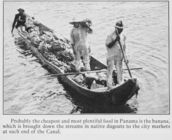
… end of the
Canal
.
topic:
Boats
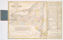
The tourist's map of the stat…
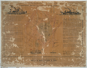
note:
… and "Stage,
canal
, and steam-
boat
register, &c."…
A view of Collect Pond and it…
note:
…. Penniman, 80 1/2
Canal
St