Click to visit the main New York Public Library Homepage
The New York Public Library
Digital Collections
About Digital Collections
Browse
Search only public domain materials
Items
Collections
Divisions
Home
Search
Browse
About
Search only public domain materials
Items
Collections
Divisions
Digital Collections
Using Images
Using Data
Search
Filtered keyword search
Show filters
Hide filters
Show Only Public Domain
topic
x
History
Boundaries
7
Nautical charts
5
Indian land transfers
3
Land grants
3
More
Less
name
Montanus, Arnoldus, 1625?-1683
18
Ogilby, John, 1600-1676
18
Barclay, Anthony, 1792-1877
7
Porter, Peter B. (Peter Buell), 1773-1844
7
United States. Light-House Board
7
More
Less
collection
Lawrence H. Slaughter Collection of English maps, charts, globes, books and atlases
40
Maps of North America
13
Maps of New York City and State
3
Atlases, gazetteers, guidebooks and other books
1
Isole famose porti: fortezze, e terre maritime sottoposte alla Ser.ma Sig.ria di Venetia, ad altri Principi Christiani, et al Sig.or Turco nouamẽnte poste in luce
1
More
Less
place
America
21
United States
18
West Indies, British
18
Canada
7
New Jersey
6
More
Less
genre
Maps
59
Nautical charts
3
Charts
1
Early works to 1800
1
Military maps
1
More
Less
publisher
Printed by the author, and are to be had at his house
18
U.S. Light-House Board
7
Buisson,
3
Printed by James Parker, and a few Copies are to be Sold by him, and Benjamin Franklin, in Philadelphia;
3
At the Presses of S. Hall, and Thomas & Andrews, and sold by E. Larkin, and the other booksellers in Boston; by Gaine & Ten Eyck, and S. Campbell, New-York; [etc.,etc.]
2
More
Less
division
Map Division
57
Rare Book Division
1
Wallach Division: Print Collection
1
type
x
cartographic
still image
2
Date Range
to
59 results found for:
x
Charts
Filtering on:
x
Topic
: History
x
Type
: cartographic
Sort by:
Relevance
Title
Date created
Date digitized
Sequence
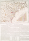
A map and
chart
of those parts of the Bay
topic:
Nautical
charts
Plan of Amelia Island in East…
note:
… & Georgia. A
chart
m
Niagara 1819
note:
…"Photolithographed from original
charts
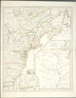
The second section of the sur…
note:
…"Photolithographed from original
charts
The Theatre of war in North A…
collection:
Charts
and maps
Theatre de la guerre en Améri…
collection:
Charts
and maps
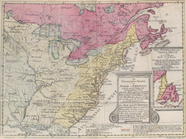
Rhode - Island, 2e feuille
topic:
Nautical
charts
m
History of the United States:…
topic:
Charts
, diagrams, etc
A sketch of the operations of…
topic:
Nautical
charts
Position der Königl; Grosbrit…
collection:
Charts
and maps
The seat of action between th…
collection:
Charts
and maps
m
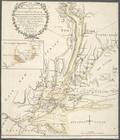
A
chart
of the harbour of Rhode Island
note:
In: Des Barres, Joseph F.W.
Charts
A plan of the operations of t…
collection:
Charts
and maps
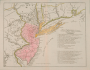
A plan of New York Island, wi…
collection:
Charts
and maps
The country twenty five miles…
collection:
Charts
and maps
Carte du theatre de la guerre…
collection:
Charts
and maps
Nova Virginiae Tabula
collection:
… of English maps,
charts
Nova Hispania Nova Galicia Gv…
collection:
… of English maps,
charts
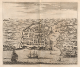
Urbs Domingo In Hispaniola
collection:
… of English maps,
charts
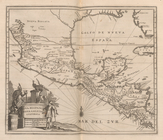
Peru
collection:
… of English maps,
charts
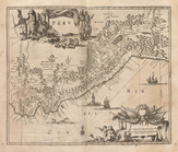
Chili
collection:
… of English maps,
charts
Paraqvaria Vulgo Paragvay Cum…
collection:
… of English maps,
charts
Brasilia
collection:
… of English maps,
charts
Urbs Salvador
collection:
… of English maps,
charts
Guiana fiue Amazonum Regio.
collection:
… of English maps,
charts
Venezuela cum parte Australi …
collection:
… of English maps,
charts
Novissima et Accuratissima To…
collection:
… of English maps,
charts
Yucatan Conventus Iuridici Hi…
collection:
… of English maps,
charts
Insulae Americanae In Oceano …
collection:
… of English maps,
charts
Novissima et Accuratissima Ja…
collection:
… of English maps,
charts
Novissima et Acuratissima Bar…
collection:
… of English maps,
charts
Terra Firma et Novum Regnum G…
collection:
… of English maps,
charts
Battle of Long Island
abstract:
…: Battle maps and
charts
Tabula Magellanica Qua Tierra…
collection:
… of English maps,
charts
Mappa Aestivarum Infularum, a…
collection:
… of English maps,
charts
Plan of the position which th…
collection:
… of English maps,
charts
m
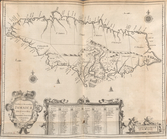
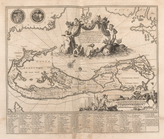
Isole famose porti: fortezze,…
topic:
Charts
, etc
Plan d'York en Virginie, avec…
collection:
… of English maps,
charts
Lloyd's new military map of t…
note:
… and
charts
for the times.
Carte d'une partie de l'Améri…
collection:
… of English maps,
charts
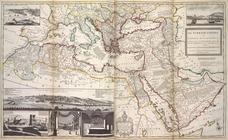
The Turkish Empire in Europe,…
collection:
… of English maps,
charts
Lake St. Clair
note:
…"Photolithographed from original
charts
m
Plate from The tapestry hangi…
collection:
…, ten
charts
Detroit 1820
note:
…"Photolithographed from original
charts
…
Charte
, auf welcher alle
note:
…"Mit einer illuminirten accuraten
Charte
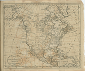
North America from the French…
collection:
… of English maps,
charts
A new map of North America sh…
collection:
… of English maps,
charts
Côte de York-town à Boston : …
collection:
… of English maps,
charts
m
Map of the St. Clair River : …
note:
…"Photolithographed from original
charts
A New map of Virginia.
collection:
… of English maps,
charts