Click to visit the main New York Public Library Homepage
The New York Public Library
Digital Collections
About Digital Collections
Browse
Search only public domain materials
Items
Collections
Divisions
Home
Search
Browse
About
Search only public domain materials
Items
Collections
Divisions
Digital Collections
Using Images
Using Data
Search
Filtered keyword search
Show filters
Hide filters
Show Only Public Domain
topic
x
Administrative and political divisions
Railroads
4
Real property
2
Altitudes
1
Canals
1
More
Less
name
Associated Railway Land Department of Florida
1
Cross, John
1
Gibbes, Charles Drayton
1
Greene, D. M. (David Maxson), 1832-1905
1
H.F. Walling's Map Establishment
1
More
Less
collection
Maps of North America
4
Maps of New York City and State
1
place
California
1
Erie Canal (N.Y.)
1
Finger Lakes Region (N.Y.)
1
Florida
1
Illinois
1
More
Less
genre
Maps
5
Cadastral maps
1
publisher
J. Cross?
1
M.H. Tyler, Publisher
1
Published by Warren Holt
1
Rand, McNally & Co
1
division
Map Division
5
type
x
cartographic
Date Range
to
5 results found for:
x
Railroad crossings
Filtering on:
x
Topic
: Administrative and political divisions
x
Type
: cartographic
Sort by:
Relevance
Title
Date created
Date digitized
Sequence
Railroad
map of Illinois, 1894-5 …
note:
…,
Railroad
and Warehouse
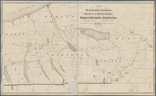
Map of south Florida : showin…
abstract:
… Associated
Railroad
Land
Map of the states of Californ…
abstract:
…,
railroads
(existing and proposed),
railroad
Map of the reservoirs, feeder…
note:
…,
railroads
, and major natural
Map of the city of Milwaukee,…
abstract:
…, streets,
railroads
, block