Click to visit the main New York Public Library Homepage
The New York Public Library
Digital Collections
About Digital Collections
Browse
Search only public domain materials
Items
Collections
Divisions
Home
Search
Browse
About
Search only public domain materials
Items
Collections
Divisions
Digital Collections
Using Images
Using Data
Search
Filtered keyword search
Show filters
Hide filters
Show Only Public Domain
topic
x
Administrative and political divisions
Piers
5
Local transit
4
Buildings
1
Ferries
1
More
Less
name
Watson, Gaylord
6
Barnard, W. S
1
G.W. & C.B. Colton & Co
1
Gilbert Elevated Railway Company
1
Mordecai, Gratz
1
More
Less
collection
Maps of New York City and State
6
place
Manhattan (New York, N.Y.)
5
New York (N.Y.)
5
New York (State)
5
Brooklyn (New York, N.Y.)
1
Hoboken (N.J.)
1
More
Less
genre
Maps
6
publisher
Lawrence G. Goulding
2
Gaylord Watson
1
Gaylord Watson, 16 Beekman St
1
John Beatson
1
Railroad gazette
1
division
Map Division
6
type
cartographic
6
Date Range
to
6 results found for:
x
Watson, W
Filtering on:
x
Topic
: Administrative and political divisions
Sort by:
Relevance
Title
Date created
Date digitized
Sequence
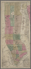
Watson
's new map of the city of Brooklyn
note:
engraved by
W
.S. Barnard.
Messrs. V.K. Stevenson & Son'…
note:
Scale approximately 1:18,498. (
W
74°01ʹ11ʺ--
W
Goulding's directory map of N…
note:
Scale not given. (
W
74°01ʹ13ʺ--
W
73°51ʹ53ʺ/N
m
Goulding's directory map of N…
note:
Scale approximately 1:18,102. (
W
74°01ʹ13ʺ--
W
m
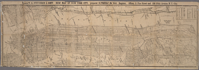
… by Gaylord
Watson
.
note:
Scale [ca. 1:14,000] (
W
74°01ʹ--
W
73°55ʹ/N
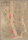
Map of New York City and surr…
note:
Scale approximately 1:18,500 (
W
74°02ʹ57ʺ--
W