Click to visit the main New York Public Library Homepage
The New York Public Library
Digital Collections
About Digital Collections
Browse
Search only public domain materials
Items
Collections
Divisions
Home
Search
Browse
About
Search only public domain materials
Items
Collections
Divisions
Digital Collections
Using Images
Using Data
Search
Filtered keyword search
Show filters
Hide filters
Show Only Public Domain
topic
x
Local transit
Railroads, Elevated
43
Streets
35
Railroads
26
Piers
18
More
Less
name
Hubacher, Max Henry, 1900-1989
29
Rand McNally and Company
7
Matthews-Northrup Works
5
G.W. & C.B. Colton & Co
4
C.S. Hammond & Company
3
More
Less
collection
Maps of New York City and State
50
Collection of photographs of New York City, New York State and more by Max Hubacher
29
place
New York (State)
50
Manhattan (New York, N.Y.)
49
New York (N.Y.)
44
Brooklyn (New York, N.Y.)
37
New York
29
More
Less
genre
Maps
50
Photographs
29
Road maps
4
Mass transit
3
Tourist maps
3
More
Less
publisher
G.W. and C.B. Colton & Co
4
The Company
4
C.S. Hammond & Co
2
E. Belcher Hyde
2
J.N. Matthews Co
2
More
Less
division
Map Division
50
Milstein Division
29
type
cartographic
50
still image
29
Date Range
to
79 results found for:
x
Street railroads
Filtering on:
x
Topic
: Local transit
Sort by:
Relevance
Title
Date created
Date digitized
Sequence
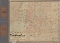
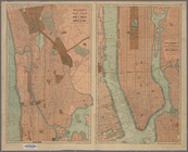
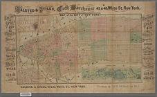
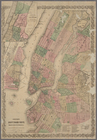
Rand McNally & Co.'s new hand…
abstract:
…
streets
, elevated
m
Authentic
street
plan of greater New
note:
Street
index on verso.
m
Hagstrom's map of Brooklyn (N…
note:
Includes
street
index.
m
New York City elevated
railroads
note:
… in the names of
streets
, route
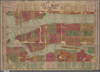
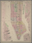
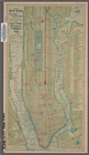
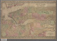
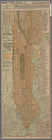
Map of the City of New York /…
note:
…
streets
,
railroads
, piers.
The Home Life Publishing Co.,…
note:
… and
street
car lines.
m
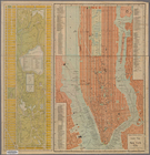
Rand, McNally & Co.'s map of …
note:
Shows
street
car
m
Hagstrom's map of Queens N.Y.…
abstract:
…
railroads
, and
street
cars
m
…
street
: showing new
note:
Street
directory, police stations, post
m
The five boroughs of the city…
note:
Margins include separate borough
street
m
…
railroads
on Manhattan
note:
… Avenue, near 193rd
Street
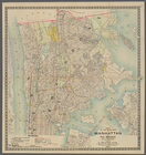
Map of boroughs of Manhattan …
note:
Includes index to Manhattan and Bronx
street
m
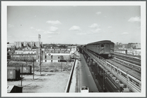
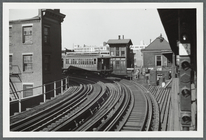
62nd
Street
station
abstract:
Tuesday, April 13, 1954, noon. 62nd
street
m
Taunton new guide map and dir…
note:
Shows
streets
m
Taunton new guide map and dir…
note:
…
Street
, New York.
Rand, McNally & Co.'s new han…
note:
Shows elevated, rapid transit and
street
m
Map of Brooklyn
note:
Street
index on verso.
Hagstrom's map of ... New Yor…
note:
Includes
street
indexes and inset map
m
New quick reference
street
indexed map
note:
…
railroads
and trolley lines.
m
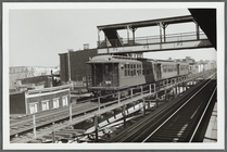
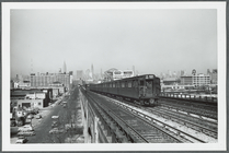
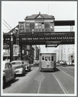
Third Avenue Elevated at 23rd
Street
abstract:
… Elevated at 23rd
Street
m
Taunton new guide map and dir…
note:
Shows
streets
m
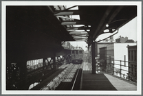
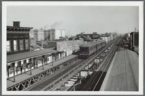
View from the N
Street
station
abstract:
… the N
Street
station
Rand McNally & Co.'s guide ma…
note:
Covers Manhattan below 113th
Street
.
m
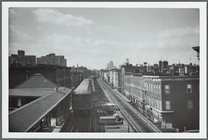
…
Street
station (looking
topic:
Railroads
, Elevated
m
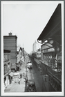
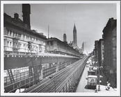
Third Avenue Elevated near 10th
Street
topic:
Streets
m
… on Myrtle
Street
[Avenue
topic:
Railroads
, Elevated
m
Elevated train on Myrtle
Street
[Avenue
topic:
Railroads
, Elevated
m
Rand, McNally & Co.'s map of …
note:
Identifies
street
m
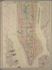
New York City map and directo…
note:
Covers Manhattan south of 113th
Street
m
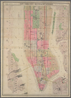
Colton's new map of the city …
note:
Shows wards, piers, elevated
railroads
m
Colton's new map of the city …
note:
Shows wards, piers, elevated
railroads
Map of the boroughs of Manhat…
abstract:
… north of 110th
Street
.
m
Westward view from the Lowery
Street
station
topic:
Streets
New York City south of 93rd
Street
abstract:
Shows wards, piers, elevated
railroads
m
Hammond's complete map of Bro…
note:
Shows
railroads
, elevated
railroads
, subways
Map of the City of New York […
note:
Covers Manhattan south of 69th
Street
.
Rand, McNally & Co.'s map of …
note:
Includes index of
street
car lines.
m
Center of New York, first cit…
note:
Covers Manhattan south of 140th
Street
.
m
Hammond's complete map of Bro…
note:
Shows
railroads
, elevated
railroads
, subways
New York and Brooklyn
note:
… and sixteenth
street
, and part of Brooklyn ; shows
streets
Center of New York, first cit…
note:
Covers Manhattan south of 140th
Street
.
Rapid transit map of Kings, Q…
note:
…
railroads
.
m
Map of the borough of Brookly…
note:
…
railroads
, trolleys, tunnels
Map of New York City: prepare…
note:
Shows Manhattan south of 130th
Street
.
Colton's New York City : Broo…
note:
Main map covers Manhattan to 125th
Street
Geographically correct map of…
note:
Shows Manhattan to 190th
Street
Map of the southern part of t…
note:
Shows
railroads
, elevated lines, ferries
m
Brooklyn, N.Y. [Nostrand Aven…
topic:
Streets
m
The Brooklyn El at Myrtle and Grand
Streets
topic:
Railroads
, Elevated
m
Third Avenue El
topic:
Streets