Click to visit the main New York Public Library Homepage
The New York Public Library
Digital Collections
About Digital Collections
Browse
Search only public domain materials
Items
Collections
Divisions
Home
Search
Browse
About
Search only public domain materials
Items
Collections
Divisions
Digital Collections
Using Images
Using Data
Search
Filtered keyword search
Show filters
Hide filters
Show Only Public Domain
topic
x
Nautical charts
Coasts
9
Fortification
2
Harbors
2
Atlases
1
More
Less
name
Bache, A. D. (Alexander Dallas), 1806-1867
8
United States Coast Survey
8
Almy, John Jay, 1815-1895
4
Robert Sayer and John Bennett (Firm)
4
Mathiot, G
3
More
Less
collection
Maps of North America
17
Lawrence H. Slaughter Collection of English maps, charts, globes, books and atlases
6
Maps of New York City and State
2
Cartographic materials from the Emmet collection of manuscripts etc. relating to American history
1
I. N. Phelps Stokes Collection of American Historical Prints
1
place
New Jersey
7
New York (N.Y.)
6
Virginia
6
Atlantic Coast
5
Atlantic Ocean
5
More
Less
genre
Maps
27
Nautical charts
12
Bathymetric maps
10
Early works to 1800
1
Portolan charts
1
More
Less
publisher
Printed for Robt. Sayer & John Bennett, sea chart & map-sellers ..
3
U.S. Coast Survey
3
U.S. Coast Survey Office
3
The United States Coast and Geodetic Survey
2
United States Coast Survey
2
More
Less
division
Map Division
26
Wallach Division: Print Collection
1
type
cartographic
27
Date Range
to
27 results found for:
x
Sea charts
Filtering on:
x
Topic
: Nautical charts
Sort by:
Relevance
Title
Date created
Date digitized
Sequence
Plan of Amelia Island in East…
note:
… & Georgia. A
chart
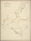
Chart
of the entrance of Hudson's River
topic:
Nautical
charts
Preliminary
chart
no. 4 of the
sea
topic:
Nautical
charts
Alaska Peninsula and Aleutian…
note:
…. Bering
Sea
Fleet
Alaska Peninsula and Aleutian…
note:
… Bering
Sea
Fleet."…
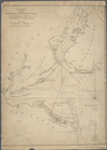
Chart
of the entrance of Hudson's River
topic:
Nautical
charts
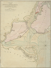
Chart
of the entrance of Hudson's River
topic:
Nautical
charts
Preliminary
chart
of the
sea
coast of North
topic:
Nautical
charts
Preliminary
chart
of the
sea
coast of part
topic:
Nautical
charts
A
chart
of the
sea
coast of New Foundland
topic:
Nautical
charts
Preliminary
chart
of the
sea
coast of South
topic:
Nautical
charts
… in the vicinity,
sea
coast
topic:
Nautical
charts
Preliminary
chart
of the
sea
coast of Virginia …
topic:
Nautical
charts
Preliminary
chart
of the
sea
coast of part
topic:
Nautical
charts
A map of the extremity of Cap…
note:
Cover the
sea
coast and Cape Cod harbor.
A
chart
of Delaware Bay and River
topic:
Nautical
charts
An actual survey of the
sea
coast from New
note:
…, as also, a new
chart
Preliminary
chart
of part of the
sea
coast
topic:
Nautical
charts
Sea
Coast of Delaware, Maryland and part
topic:
Nautical
charts
Beaufort Harbour, North Carol…
abstract:
… detail and profile of
sea
A
chart
of the
sea
coast of New Foundland
topic:
Nautical
charts
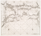
A
chart
of the
sea
coasts of New-England
topic:
Nautical
charts
A
chart
of Delaware Bay and River
topic:
Nautical
charts
… by land and
sea
topic:
Nautical
charts
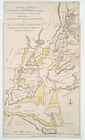
Chart
and plan of the harbour of New York
topic:
Nautical
charts
A general
chart
of the West India's [sic]
topic:
Nautical
charts
Pas-kaart vande zee kusten va…
note:
From Johannes van Keulen,
Sea
-atlas, ca
End of results
|
Top