Click to visit the main New York Public Library Homepage
The New York Public Library
Digital Collections
About Digital Collections
Browse
Search only public domain materials
Items
Collections
Divisions
Home
Search
Browse
About
Search only public domain materials
Items
Collections
Divisions
Digital Collections
Using Images
Using Data
Search
Filtered keyword search
Show filters
Hide filters
Show Only Public Domain
topic
x
Railroads
Administrative and political divisions
26
Roads
12
Indian reservations
11
Local transit
10
More
Less
name
Rand McNally and Company
14
United States. General Land Office
9
Bien, Julius, 1826-1909
7
G.W. & C.B. Colton & Co
6
C.S. Hammond & Company
5
More
Less
collection
Maps of North America
56
Maps of New York City and State
28
Maps of North and South America
1
place
New York (State)
27
New York
14
New York (N.Y.)
13
Brooklyn (New York, N.Y.)
11
Manhattan (New York, N.Y.)
10
More
Less
genre
Maps
85
Tourist maps
3
Geological maps
2
Mass transit
2
Road maps
2
More
Less
publisher
publisher not identified
5
General Land Office
4
Rand, McNally & Co
4
S.R. Stoddard
4
C.S. Hammond & Co
3
More
Less
division
Map Division
85
type
x
cartographic
still image
1
Date Range
to
85 results found for:
x
S. W
Filtering on:
x
Topic
: Railroads
x
Type
: cartographic
Sort by:
Relevance
Title
Date created
Date digitized
Sequence
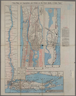
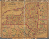
County & township map of the …
note:
Drawn and engraved by
W
.H. Gamble.
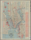
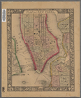
Plan of New York &c.
note:
Scale not given. (
W
74°02ʹ59ʺ--
W
73°56ʹ48ʺ/N
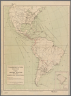
Transportation routes between…
note:
Scale not given (
W
132°52ʹ00ʺ--
W
32°23ʹ00ʺ/N
m
Map of the city of Brooklyn
note:
Scale approximately 1:21,250 (
W
74°01ʹ40ʺ--
W
Official railroad map of Nebr…
note:
…. L.
W
. Gilchrist, J. R. Gilkeson,
W
.
S
Map of Indian Territory
note:
Scale approximately 1:1,500,000 (
W
100°02ʹ--
W
Map of the rail-roads of the …
note:
Scale not given (
W
80°12ʹ--
W
71°47ʹ/N 45°44
Chapman's sectional map of Wi…
note:
… miles to an inch (
W
92°40ʹ--
W
86°50ʹ/N 46°50
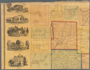
Mitchell's county and townshi…
note:
title engd. by
W
.Williams, map engraver
m
County & township map of the …
note:
Drawn and engraved by
W
.H. Gamble
m
Watson's new map of New York …
note:
Scale approximately 1:18,000. (
W
74°04ʹ09ʺ--
W
Map of the rail roads of the …
note:
Scale approximately 1:1,000,000 (
W
80°20ʹ--
W
71°20
Indian Territory
note:
… miles to 1 inch (
W
100°02ʹ--
W
94°25ʹ/N 37°00
m
Taunton new guide map and dir…
note:
Scale [ca. 1:18,400]. (
W
74°01ʹ13ʺ--
W
73°57
m
Taunton new guide map and dir…
note:
Scale [ca. 1:18,432]. (
W
74°03ʹ30ʺ--
W
73°56
m
Taunton new guide map and dir…
note:
Scale [ca. 1:18,400]. (
W
74°01ʹ13ʺ--
W
73°57
m
Schuyler County, New York, wi…
note:
… by
S
.N. Beers ; Lith by
W
.H. Rease, N.E. cor 4
McClung's map of Minnesota : …
note:
… in the year 1870 by J.
W
United States of America
note:
…"Title cartouche engraved by J.
W
. Steel."…
m
Rand, McNally & Co.'
s
map showing one
note:
… miles to 1 inch (
W
77°32ʹ--
W
73°34ʹ/N 41°10ʹ--N
m
United States of America, 1834
note:
Title cartouche engraved by J.
W
. Steel.
Freight terminal map of the P…
note:
Scale 1:55,000 (
W
74°17ʹ24ʺ--
W
73°40ʹ54ʺ/N
Post route map of the state o…
note:
… the direction of
W
.L. Nicholson
Map of the proposed line of r…
note:
Made by
W
. Vaisz, top. eng
Correct map of Texas
note:
Scale not given (
W
106°38ʹ--
W
93°30ʹ/N 36°30
Map showing the principal rai…
note:
Scale approximately 1:12,000,000 (
W
129°--
W
63°/N
Rand, McNally & Co.'
s
new handy map
note:
Scale approximately 1:25,500 (
W
74°02ʹ41ʺ--
W
A new map of the United State…
note:
compiled, drawn & engraved by
W
. Williams
Map of the state of Wisconsin
note:
….
S.W
. Lamoreux
Rand McNally & Co.'
s
North Dakota
note:
Scale approximately 1:1,125,000 (
W
104°03ʹ--
W
m
Map of the consolidated City …
note:
Scale [ca. 1:22,352] (
W
74°01ʹ--
W
73°53ʹ/N
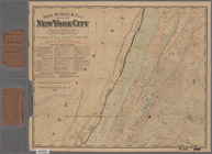
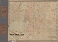
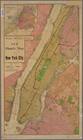
Map of New York City : showin…
note:
Scale approximately 1:45,000. (
W
74°04ʹ42ʺ--
W
m
Rand, McNally & Co.'
s
complete map
note:
Scale approximately 1:25,000 (
W
74°02ʹ43ʺ--
W
Rand, McNally & Co.'
s
new automobile
note:
Scale approximately 1:93,000 (
W
74°41ʹ33ʺ--
W
Map of the state of Wisconsin
note:
….
S.W
. Lamoreux
m
Hammond's new guide map of Ma…
note:
Scale approximately 1:36,000. (
W
74°01ʹ22ʺ--
W
m
The Wanamaker diary map of Ne…
note:
Scale approximately 1:34,000 (
W
74°01ʹ22ʺ--
W
Rand, McNally & Co.'
s
Minnesota
note:
Scale approximately 1:1,550,000 (
W
97°--
W
90°/N
Track map of the trolley line…
note:
… inches = 1 mile (
W
74°12ʹ09ʺ--
W
74°02ʹ39ʺ/N
m
Rand, McNally & Co.'
s
map of New York
note:
Scale [ca. 1:25,000] (
W
74°05ʹ36ʺ--
W
73°52
m
Rand, McNally & Co.'
s
map of New York
note:
Scale [ca. 1:25,000] (
W
74.08°--
W
73.87°/N
m
Rand, McNally & Co.'
s
Minnesota
note:
Scale approximately 1:1,000,000 (
W
97°15ʹ--
W
89°30
Map of Kansas
note:
Scale approximately 1:1,520,000 (
W
102°25ʹ--
W
A map of part of Alabama & Fl…
note:
…, U.
S
. Asst. Civil Engr.
m
Street guide of Manhattan and…
note:
Scale approximately 1:30,000 (
W
74°01ʹ19ʺ--
W
Geological map of Alabama
note:
…, A.M. Gibson, Daniel
W
Map of Wisconsin showing the …
note:
Scale approximately 1:1,700,000 (
W
93°10ʹ--
W
86°50
Rand, McNally & Co.'
s
Illinois …
note:
Scale approximately 1:950,000 (
W
91°50ʹ--
W
87°01
A new map of Pennsylvania : w…
note:
by H.
S
. Tanner ; engraved by
W
. Brose
m
The travellers pocket map of …
note:
Scale approximately 1:2,100,000 (
W
90°25ʹ--
W
82°15