Click to visit the main New York Public Library Homepage
The New York Public Library
Digital Collections
About Digital Collections
Browse
Search only public domain materials
Items
Collections
Divisions
Home
Search
Browse
About
Search only public domain materials
Items
Collections
Divisions
Digital Collections
Using Images
Using Data
Search
Filtered search
Show filters
Hide filters
Show Only Public Domain
topic
x
Coal mines and mining
Railroads
9
Geology
6
Anthracite coal
5
Canals
5
More
Less
name
Geological Survey of Pennsylvania
4
Fisher, Samuel, B
3
Hart, Lane S
3
Julius Bien & Co
3
Lesley, J. P. (J. Peter), 1819-1903
3
More
Less
collection
Maps of North America
23
Conditions in the Paint Creek district, West Virginia: Hearings before a subcommittee of the Committee on Education and Labor, United States Senate, Sixty-third Congress, first session, pursuant to S. res. 37, a resolution authorizing the appointment of a committee to make an investigation of conditions in the Paint Creek district, West Virginia [June 2-Oct. 29, 1913]
1
place
Pennsylvania
13
Middle Atlantic States
4
West Virginia
3
Illinois
2
Indiana
2
More
Less
genre
Maps
23
Geological maps
6
Diagrams
4
Topographic maps
3
Charts
2
More
Less
publisher
publisher not identified
5
Geological Survey of Pennsylvania
2
Geological Survey of Pennsylvania?
2
Ackerman Lith
1
Benj. Smith Lyman
1
More
Less
division
Map Division
23
General Research Division
1
type
cartographic
23
still image
1
Date Range
to
24 results found
Filtering on:
x
Topic
: Coal mines and mining
Sort by:
Title
Date created
Date digitized
Sequence
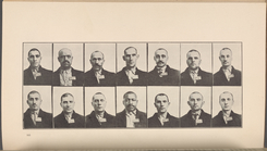
Portraits of the coal miners
Profiles of the canals and ra…
Profiles of the canals and ra…
Map of the canals and rail ro…
The gold and coal fields of A…
Map of the Cumberland coal re…
Cumberland coal region: shewi…
[S]econd Geolo[gical Survey o…
A geological and topographica…
A geological and topographica…
Map of the mines, canals, and…
Map of the Clinton County Coa…
Geological and topographical …
General map of the anthracite…
m
Map of the first and second a…
Map of the first and second a…
Map of the first and second a…
Topographical map of the coal…
Geological and sectional map …
No. 1, diagram of coal measur…
Map of the Indiana North and …
Map of Vanderburgh County, In…
Map of the Kanawha Mining Com…
m
Title map of the coal field o…
End of results
|
Top