Click to visit the main New York Public Library Homepage
The New York Public Library
Digital Collections
About Digital Collections
Browse
Search only public domain materials
Items
Collections
Divisions
Home
Search
Browse
About
Search only public domain materials
Items
Collections
Divisions
Digital Collections
Using Images
Using Data
Search
Filtered search
Show filters
Hide filters
Show Only Public Domain
topic
x
Maps
Real property
214
Insurance, Fire
38
Landowners
26
Administrative and political divisions
25
More
Less
name
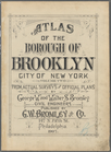
G.W. Bromley & Co
275
Bromley, George Washington
87
Bromley, Walter Scott
87
Geological Survey (U.S.)
52
Perris, William
38
More
Less
collection
Atlases of New York City
350
Atlases, gazetteers, guidebooks and other books
71
Atlases of the United States
53
Maps of North America
46
Maps of New York City and State
43
More
Less
place
New York (N.Y.)
238
New York (State)
225
Bronx (New York, N.Y.)
188
Brooklyn (New York, N.Y.)
125
New Jersey
80
More
Less
genre
Maps
582
Atlases
56
Manuscript maps
27
Surveys
25
Illustrations
11
More
Less
publisher
G.W. Bromley & Co
275
The Suvery
52
William Perris
38
M.B. Brown Printing & Binding Co.,
37
Printed for John Stockdale, Piccadilly. T. Gillett, Printer, Salisbury Square
28
More
Less
division
Map Division
570
General Research Division
14
Rare Book Division
13
Schomburg Manuscripts, Archives and Rare Books Division
4
Schomburg Jean Blackwell Hutson Research and Reference Division
3
More
Less
type
cartographic
584
text
27
still image
13
Date Range
to
607 results found
Filtering on:
x
Topic
: Maps
Sort by:
Title
Date created
Date digitized
Sequence
Map of the country thirty thr…
Map of the country thirty thr…
Map of the country thirty thr…
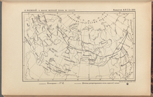
A map of Barbary comprehendin…
Map showing the boundary of t…
Bounded by Avenue K., Ralph A…
Bounded by E. 103rd Street, A…
Bounded by Avenue D., Ralph A…
Bounded by Rockaway Avenue, R…
Bounded by Ralph Avenue, E. 9…
Bounded by Avenue J., E. 56th…
Bounded by Avenue P., E. 31st…
Bounded by Avenue V., Knapp S…
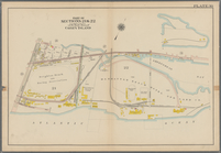
Coney Island: Part of Section…
Coney Island. Bounded by Cana…
Bounded by Bay View Avenue, W…
Bounded by Ocean Avenue, Emmo…
Bounded by Ocean Parkway, Ave…
Bounded by Avenue Q., Ocean A…
Bounded by Avenue M., Coney I…
Bounded by Avenue I., Ocean A…
Bounded by (Vanderveer Park) …
Bounded by Ditmas Avenue, Con…
Bounded by Regent Place, Tild…
Bounded by Albemarle Avenue, …
Bounded by Winthrop Street, (…
Bounded by Malbone Street, Ki…
Bounded by Terrace Place, 11t…
Bounded by 86th Street, W. 9t…
Bounded by 86th Street, W. 11…
Bounded by 72nd Street, 22nd …
Bounded by 58th Street, West …
Bounded by 86th Street, 20th …
Bounded by 85th Street, 1st A…
Bounded by 72nd Street, 21st …
Bounded by 58th Street, 21st …
Bounded by 43rd Street, West …
Bounded by 72nd Street, Fourt…
Bounded by 58th Street, Fourt…
Bounded by 43rd Street, 14th …
Bounded by (Greenwood Cemeter…
Bounded by Mackay Pl., 1st Av…
Bounded by 60th St., Seventh …
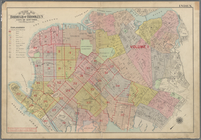
Outline Map of the Borough of…
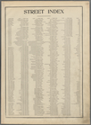
Street Index. [Albany Avenue …
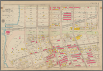
Atlas of the Borough of Brook…
Bounded by Stanley Ave., Mill…
Bounded by Riverdale Avenue, …
Bounded by Linwood St., Cozin…
Bounded by Logan Street, Jama…
1
2
3
Previous
Next
1
2
3
Previous
Next