Click to visit the main New York Public Library Homepage
The New York Public Library
Digital Collections
About Digital Collections
Browse
Search only public domain materials
Items
Collections
Divisions
Home
Search
Browse
About
Search only public domain materials
Items
Collections
Divisions
Digital Collections
Using Images
Using Data
Search
Filtered search
Show filters
Hide filters
Show Only Public Domain
topic
x
Population
African Americans
30
Social conditions
22
History
17
Slavery
16
More
Less
name
Hospital Council of Greater New York
38
New York (N.Y.). City Planning Commission
38
New York (N.Y.). Department of City Planning
38
Graham, H. S. (Henry S.)
3
Hergesheimer, E. (Edwin)
3
More
Less
collection
Atlases of New York City
38
Maps of New York City and State
17
Maps of North America
14
Miscellaneous American Letters and Papers (MALP)
12
The Negro American family
10
More
Less
place
New York (N.Y.)
45
New York (State)
26
United States
11
New York
8
Manhattan (New York, N.Y.)
7
More
Less
genre
Maps
74
Documents
12
Illustrations
12
Statistics
5
Manuscript maps
3
More
Less
publisher
The Atlanta University Press
10
producer not identified
3
publisher not identified
3
A. R. Ohman Map Co., H.B. Petersen, Daughtsmen & Engravers,
2
Henry S. Graham
2
More
Less
division
Map Division
71
Schomburg Jean Blackwell Hutson Research and Reference Division
16
Schomburg Manuscripts, Archives and Rare Books Division
14
Wallach Division: Photography Collection
1
type
cartographic
74
text
61
still image
3
Date Range
to
102 results found
Filtering on:
x
Topic
: Population
Sort by:
Title
Date created
Date digitized
Sequence
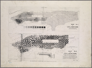
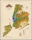
Urban development of the City…
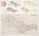
Czechoslovakia
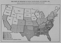
Per cent of Negroes in total …
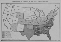
Percentage of Negroes in the …
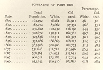
Appendix D, Population of Por…
Block distribution of childre…
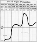
Slavery; Sex of Negro populat…
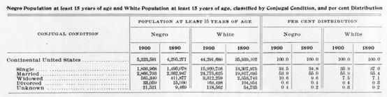
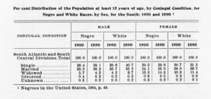
Negro population at least 15 …
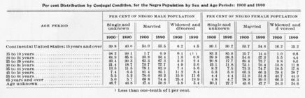
Per cent distribution by conj…
Per cent distribution of the …
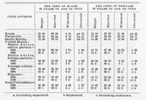
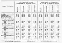
Conjugal condition; Negroes o…
Conjugal condition of the Neg…
Size of the family; [Per cent…
Size of the family; [Per cent…
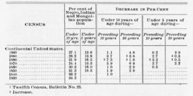
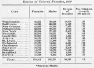
Excess of Colored females, 19…
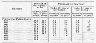
Negro population, at least te…
m
Population and school attenda…
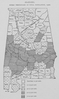
Alabama. Negro percentage of …
m
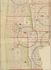
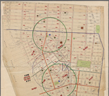
Map of part of New York City …
m
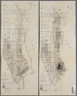
Map[s] to accompany report "T…
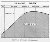
The wave of Negro immigration
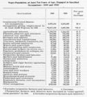
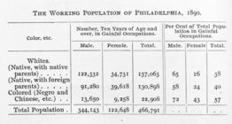
The working population of Phi…
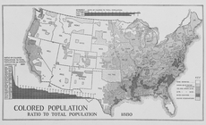
Colored population ratio to t…
m
The Tenement-House Committee …
Outline map of Massachusetts:…
Surveys for a future water su…
Map showing Indian reservatio…
Watson's new map of Brooklyn …
Map of the state of South Car…
m
Map showing Indian reservatio…
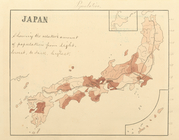
Japan, population, showing th…
Map of Kansas
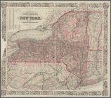
Colton's railroad & township …
Map showing, in five degrees …
Map of Pennsylvania showing p…
Colton's railroad & township …
Map of Wisconsin designed to …
Map of Virginia showing the d…
Map showing the distribution …
Map of Virginia : showing the…
Census of the State of New Yo…
m
A new map of Arkansas with it…
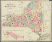
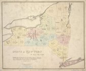
Map of the State of New-York …
Map of Texas and the countrie…
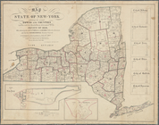
State of New York : in Senate…
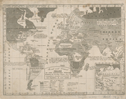
Moral and political chart of …
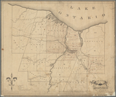
County of Monroe
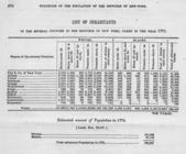
List of inhabitants in the se…
General list of inhabitants i…
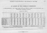
An account of the number of i…