Click to visit the main New York Public Library Homepage
The New York Public Library
Digital Collections
About Digital Collections
Browse
Search only public domain materials
Items
Collections
Divisions
Home
Search
Browse
About
Search only public domain materials
Items
Collections
Divisions
Digital Collections
Using Images
Using Data
Search
Filtered keyword search
Show filters
Hide filters
Show Only Public Domain
topic
Geography
53
Description and travel
20
History
20
Business enterprises
9
Commerce
9
More
Less
name
Moll, Herman, -1732
44
Childe, Timothy
43
Falconer, Robert, active 1700
43
Luyts, Jan, 1655-1721
43
Green, John, fl. 1730-1753
11
More
Less
collection
Lawrence H. Slaughter Collection of English maps, charts, globes, books and atlases
71
A new general collection of voyages and travels: consisting of the most esteemed relations, which have been hitherto published in any language; comprehending everything remarkable in its kind, in Europe, Asia, Africa, and America
11
New York City directories
9
Description de l'Égypte: ou, Recueil des observations et des recherches qui ont été faites en Égypte pendant l'expédition de l'armée française
7
Incidents of travel in Yucatan: By John L. Stephens ... Illustrated by 120 engravings...
7
More
Less
place
United States
15
Africa
14
New York (State)
13
North America
12
Egypt
11
More
Less
genre
Maps
174
Illustrations
79
Prints
37
Books
15
Directories
9
More
Less
publisher
Printed for Timothy Childe at the White Hart at the West-end of St. Paul's Church-yard
43
Harper & Brothers
12
Printed for T. Astley
11
Impr. impériale
7
Printed for Robert Morden and Thomas Cockeril, at the Atlas in Cornhill, and at the Three Legs in the Poultrey, over against the Stocks-Market
6
More
Less
division
Map Division
87
Rare Book Division
59
Schomburg Manuscripts, Archives and Rare Books Division
29
Schomburg Jean Blackwell Hutson Research and Reference Division
4
General Research Division
3
More
Less
type
x
cartographic
still image
32
text
19
Date Range
to
183 results found for:
x
Book illustrations
Filtering on:
x
Type
: cartographic
Sort by:
Relevance
Title
Date created
Date digitized
Sequence
m
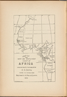
Opening Africa
collection:
…'s
Books
: Selections from
m
South and Central Africa
collection:
…'s
Books
: Selections from
m
With the 114th in the ETO: A …
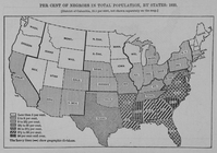
Per cent of Negroes in total …
collection:
Negro year
book
: an annual encyclopedia
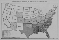
Percentage of Negroes in the …
collection:
Negro year
book
: an annual encyclopedia
m
Atlas of the
illustrated
building laws
The Political Division of Afr…
Map of the West and South-Wes…
Farrar's map of northern Main…
note:
…: Farrar's
illustrated
guide
book
to Moosehead
Hints for the lay-out of East…
note:
…. Punderson,
Book
and job
… and Dealer in
Books
Plan of the grounds and build…
note:
…, by the 'Centennial Guide
Book
Company
…. Sears, Dealer in
Books
note:
…., New York,
illustrated
.
Plan of the grounds and build…
note:
…, by the 'Centennial Guide
Book
Company
Siege of Fort Meigs
note:
Illustrated
half-title.
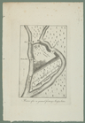
Detroit River and vicinity
note:
Illustrated
half-title.
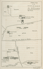
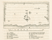
Plan of the Tippecanoe camp a…
note:
Illustrated
half-title.
Plan of the Battle of Fallen …
note:
Illustrated
half-title.
Battle of the Thames
note:
Illustrated
half-title.
Plan goroda Vil’ny pervoi pol…
Plan goroda Liublina.
Gorod Kholm v XVII v. S gravi…
m
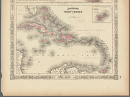
Johnson's West Indies, Plate …
collection:
Atlases, gazetteers, guidebooks and other
books
m
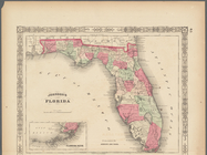
Johnson's Florida, Plate 43
collection:
Atlases, gazetteers, guidebooks and other
books
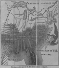
Map of free states, slave sta…
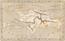
Map of Hispaniola. Hayti or S…
note:
Added t.-p.,
illustrated
.
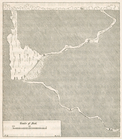
Map of the country thirty thr…
note:
Purchase; High Ridge
Books
, 120 North
Distance map of the state of …
note:
Purchase; High Ridge
Books
; 2011/12/29
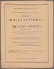
Turkey III: containing the So…
collection:
…, globes,
books
and atlases
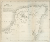
Map of Yucatan
collection:
…. Stephens ...
Illustrated
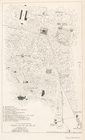
Plan of Uxmal
collection:
…. Stephens ...
Illustrated
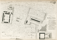
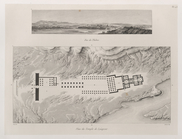
General plan of the ruins of …
collection:
…. Stephens ...
Illustrated
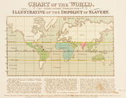
Slavery is a dark spot on the…
Ancient Indian map of Mani
collection:
…. Stephens ...
Illustrated
General plan of the buildings…
collection:
…. Stephens ...
Illustrated
Section of the cave
collection:
…. Stephens ...
Illustrated
Plan of the City wall
collection:
…. Stephens ...
Illustrated
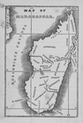
Map of Madagascar
m
…
illustrated
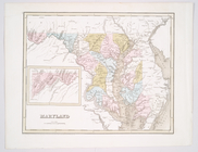
Maryland
note:
Possibly from T.G. Bradford's An
illustrated
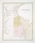
Delaware
note:
Appears in Bradford's An
illustrated
atlas
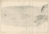
The Nile, from Assuan to the …
collection:
… ; and
illustrating
the antiquities
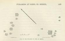
General plan of the pyramids …
collection:
… ; and
illustrating
the antiquities
Plan of the pyramids of Gibel…
collection:
… ; and
illustrating
the antiquities
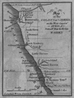
Map of the Colony of Liberia …
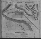
Plan of the Town of Monrovia
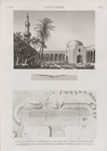
1. Vue de Thèbes. 2. Plan du …
Ruiner efter en gammal fastni…
Chart of the world, on Mercat…
Alexandrie [Alexandria]. 1. V…