Click to visit the main New York Public Library Homepage
The New York Public Library
Digital Collections
About Digital Collections
Browse
Search only public domain materials
Items
Collections
Divisions
Home
Search
Browse
About
Search only public domain materials
Items
Collections
Divisions
Digital Collections
Using Images
Using Data
Search
Filtered keyword search
Show filters
Hide filters
Show Only Public Domain
topic
Administrative and political divisions
8
Nautical charts
6
Discovery and exploration
5
Landowners
5
Real property
4
More
Less
name
Geological Survey (U.S.)
5
United States. Congress (55th, 3rd session : 1898-1899)
5
Walcott, Charles D. (Charles Doolittle), 1850-1927
5
Post, W. S
4
Spurr, Josiah Edward, 1870-1950
4
More
Less
collection
Maps of North America
20
Maps of New York City and State
5
Atlases of the United States
1
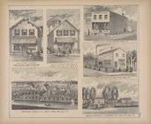
Glimpses of Africa, West and Southwest coast: containing the author's impressions and observations during a voyage of six thousand miles from Sierra Leone to St. Paul de Loanda and return, including the Rio del Ray and Cameroons rivers, and the Congo River, from its mouth to Matadi
1
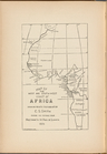
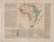
L' Afrique avec ses divisions geographiques, les colonies européennes, &c.&c
1
More
Less
place
Alaska
6
New York (State)
6
Connecticut
3
Adirondack Mountains (N.Y.)
2
Atlantic Coast
2
More
Less
genre
Maps
30
Topographic maps
7
Nautical charts
5
Bathymetric maps
4
Cadastral maps
2
More
Less
publisher
U.S. Congress
5
Northern Transcontinental Survey?
2
S.R. Stoddard
2
U.S. Coast Survey office
2
A. M. E. Sunday School Union
1
More
Less
division
Map Division
27
Schomburg Jean Blackwell Hutson Research and Reference Division
2
Schomburg Manuscripts, Archives and Rare Books Division
1
type
x
cartographic
text
2
still image
1
Date Range
to
30 results found for:
x
Center, E. C
Filtering on:
x
Type
: cartographic
Sort by:
Relevance
Title
Date created
Date digitized
Sequence
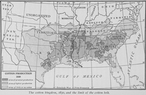
The cotton kingdom, 1850, and…
parent:
864f2480-
c
627-012f-3061-58d385a7bc34
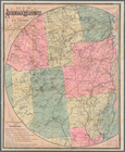
Map of Bennington County, Ver…
parent:
4162
e
680-
c
52b-012f-
c
2dc-3
c
075448cc4b
Map of Newport, R.I.
parent:
4162
e
680-
c
52b-012f-
c
2dc-3
c
075448cc4b
Preliminary chart of Calibogu…
parent:
4162
e
680-
c
52b-012f-
c
2dc-3
c
075448cc4b
m
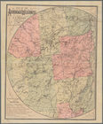
Map of Tolland County, Connec…
parent:
4162
e
680-
c
52b-012f-
c
2dc-3
c
075448cc4b
m
A new map of Indiana : exhibi…
parent:
4162
e
680-
c
52b-012f-
c
2dc-3
c
075448cc4b
… Touched at by
C
.S. Smith
parent:
a6eded40-
c
025-0132-90d6-58d385a7bbd0
Middle part of Long Island So…
parent:
587bdb60-
c
5aa-012f-f824-58d385a7bc34
m
Post route map of the states …
parent:
4162
e
680-
c
52b-012f-
c
2dc-3
c
075448cc4b
Map of the Adirondack wildern…
parent:
f2250050-7f21-0133-
c
228-00505686a51
c
Survey of the entrance to Mil…
parent:
4162
e
680-
c
52b-012f-
c
2dc-3
c
075448cc4b
Map of the Adirondack wildern…
parent:
41bdda20-
c
5aa-012f-4dde-58d385a7bc34
m
Eastern part of Long Island S…
parent:
45ed47
e
0-793
c
-0135-6bfd-47d71542dbac
A topographical map of Steube…
parent:
c
8686260-
e
544-0133-38
e
5-00505686a51
c
Map of Franklin County, Massa…
parent:
4162
e
680-
c
52b-012f-
c
2dc-3
c
075448cc4b
Alaska route of military expe…
parent:
d6d5
c
350-fd3
e
-0135-d061-5d18a13
c
74ff
Map no. IV, Laos airfields
parent:
94
e
61950-
c
6d0-012f-5b88-58d385a7bc34
… colonies européennes, &
c
.&
c
parent:
2eb10f40-ee88-0131-a2
e
5-58d385a7b928
Survey of the mouth of Trail …
parent:
4162
e
680-
c
52b-012f-
c
2dc-3
c
075448cc4b
Store of Leroy S. Oatman, Dru…
parent:
cc0bf790-
c
5f7-012f-93b3-58d385a7bc34
Map of Taunton: [Massachusett…
parent:
54
c
697
e
0-6ba6-0134-df63-00505686a51
c
Sketch showing the progress o…
parent:
4162
e
680-
c
52b-012f-
c
2dc-3
c
075448cc4b
General chart of Alaska : com…
parent:
8
c
4b3
e
60-fd43-0135-a34
e
-09d186a3eb8b
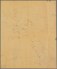
Explorations in Alaska, 1898 …
parent:
4162
e
680-
c
52b-012f-
c
2dc-3
c
075448cc4b
Explorations in Alaska, 1898 …
parent:
6bfef1
e
0-fd3
c
-0135-7811-05892325697
c
Explorations in Alaska, 1898 …
parent:
4162
e
680-
c
52b-012f-
c
2dc-3
c
075448cc4b
Explorations in Alaska, 1898 …
parent:
a3fdc6
e
0-fd3d-0135-
e
2b6-0bb5
c
166aabe
Preliminary agricultural map …
parent:
4162
e
680-
c
52b-012f-
c
2dc-3
c
075448cc4b
m
Preliminary agricultural map …
parent:
4162
e
680-
c
52b-012f-
c
2dc-3
c
075448cc4b
The Cornucopia map : showing …
parent:
4162
e
680-
c
52b-012f-
c
2dc-3
c
075448cc4b
End of results
|
Top